The Beagle Beach Well
ABSTRACT
Having reviewed the day’s finds and findings, it is safe to say that we found no direct trace of the Beagle. Some wine bottle glass may broadly fit the 1839 date and odd pieces of lead and copper patching containing round nail holes may be from the period but probably later. Nothing with the signature ‘broad arrow’ Admiralty mark. Almost no modern rubbish – some fishing tackle and WW2 debris but generally very clean. The tube of a used powder fire extinguisher - >1912 – that has either been used for target practice or perforated by the Japs as the rounds are 303 or thereabouts but seemingly of poor quality as some failed to exit the tube. There is a large piece of what appears to be riveted aviation aluminium tight in the rocks at the east end of the beach. I first thought allied drop tank but it is good quality and a sandwich section suggests aileron. The Japanese alone had the technology to weld aluminium so Allied aircraft is suggested and it is insular. Off Marchinbar, where Japanese aircraft were shot down, we have found small pieces of aluminium buried under rocks suggesting that the craft has broken up to a considerable extent upon surface impact & transit to shore.
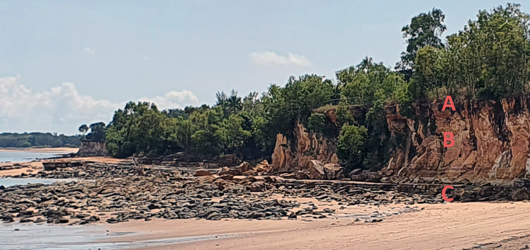
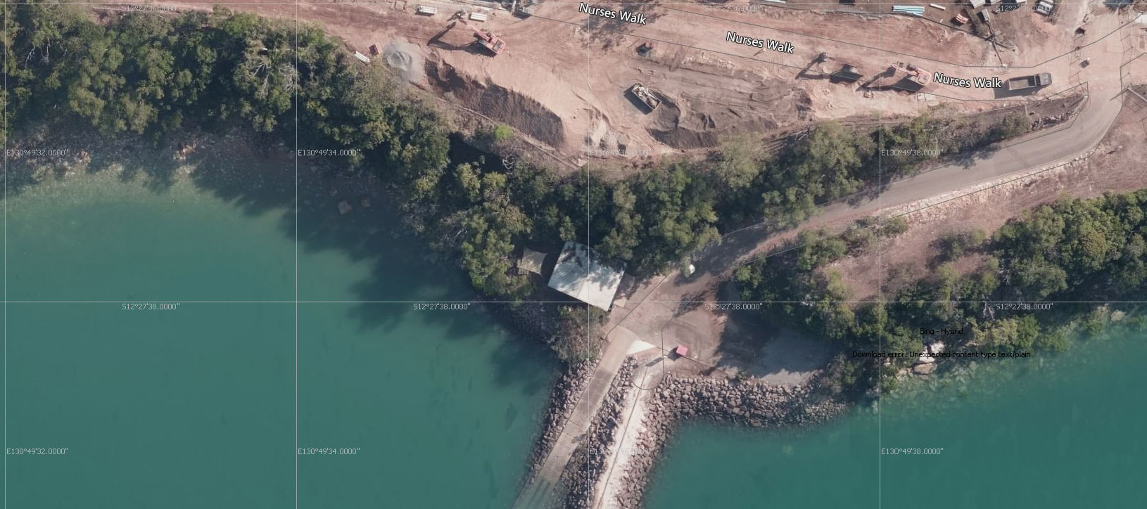
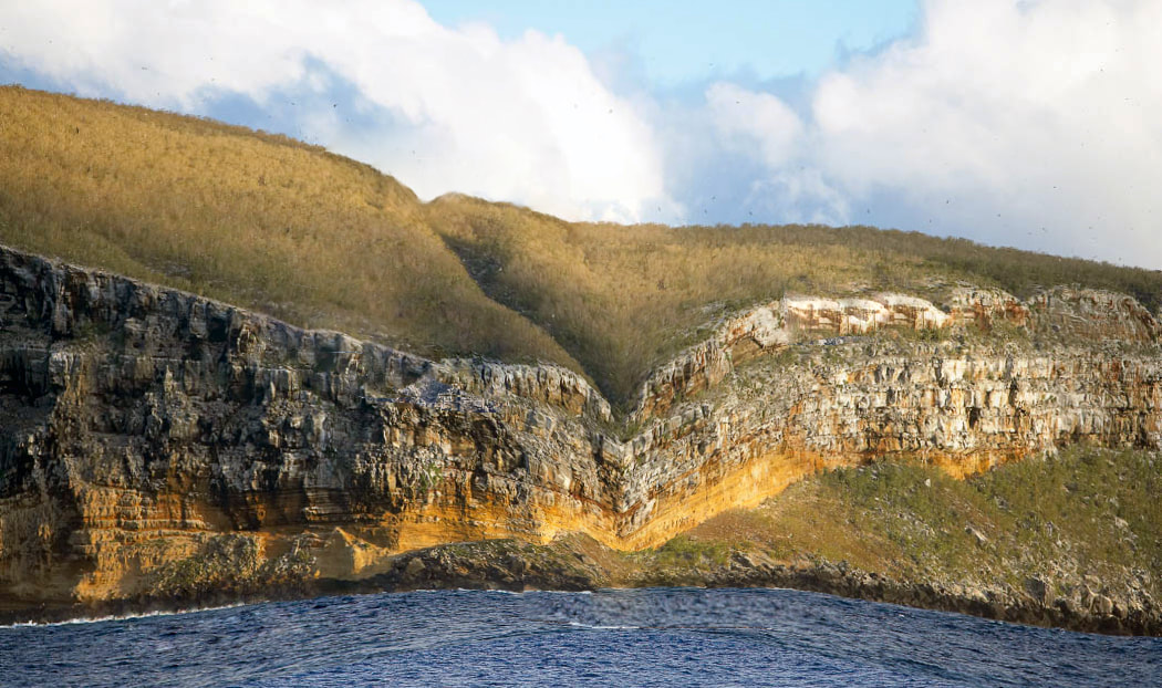
The geology is the same as the general area though the cliffs are heavily vegetated and there is considerable large tumble onto the beach. We did not inspect the top of the cliff though TS made extensive forays up the cliff and along the short terraces. The attached image show extensive earthworks have altered the clifftop area.
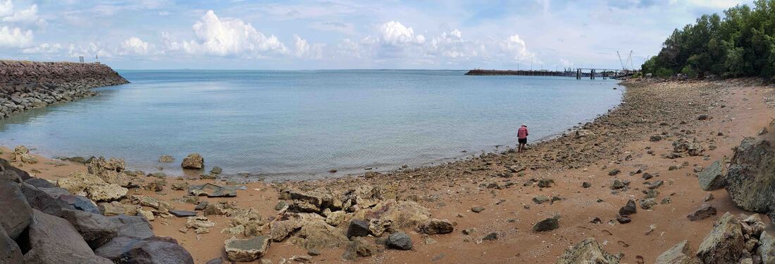
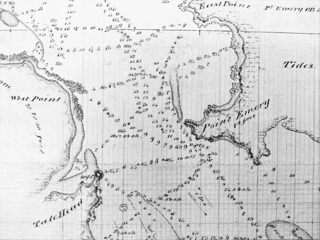
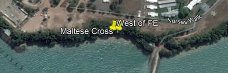
At the centre of the beach – beneath the Maltese Cross – there is an interesting deposit of broken coral from an unknown reef perhaps sorted by the adjacent sea walls – a heavy tumble of rocks – high cliff face out of which sprout two large paperbark trees parallel to the beach. There is considerable water here but no evidence of interference other than from a pair of Bush Chooks who have an active mound - a little to the east. TS was particularly impressed by this spot but the cliff is too high for drilling from above and the documents state that the sights were taken from the centre of the beach whilst the well (wells) was in a gully at the eastern end where the groyne and boat ramp are capped by a building & hard-standing area built on boulders imported from Mt Bundy. At the back of the building there is a covered verandah area – behind which is a large Weeping Fig growing out of the cliff – proof of permanent water. This parking area level is serviced by a steep, sealed road to the clifftop.
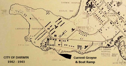
Peter Jolly - who is renowned for his work with Water Resources - came over to spend several hours with us going through the survey of the beach. We last met 45 years ago in Alice Springs so there was some catching up and broader discussion of surface water penetration - he and TS talk the same language. The difficulty lay in understanding the minute description of what the men dug through to construct the 25ft well half way down a gully which could be approached by crawling on the stomach to reveal water in the bottom. Peter had remarked that it is usual for cliff gullies to channel water and erode – which in turn affords easy access to the beach and often turns into a path – the penny dropped as in this case the gully has become a steep sealed road and the platform at about 25ft above the hightide level is a carpark and hardstand atop the boat ramp.
So now we know where the Beagle Well is buried but - unlike Richard III - it is going to stay in a carpark for many years to come.
The geology is the same as the general area though the cliffs are heavily vegetated and there is considerable large tumble onto the beach. We did not inspect the top of the cliff though TS made extensive forays up the cliff and along the short terraces. The attached image show extensive earthworks have altered the clifftop area.
At the centre of the beach – beneath the Maltese Cross – there is an interesting deposit of broken coral from an unknown reef perhaps sorted by the adjacent sea walls – a heavy tumble of rocks – high cliff face out of which sprout two large paperbark trees parallel to the beach. There is considerable water here but no evidence of interference other than from a pair of Bush Chooks who have an active mound - a little to the east. TS was particularly impressed by this spot but the cliff is too high for drilling from above and the documents state that the sights were taken from the centre of the beach whilst the well (wells) was in a gully at the eastern end where the groyne and boat ramp are capped by a building & hard-standing area built on boulders imported from Mt Bundy. At the back of the building there is a covered verandah area – behind which is a large Weeping Fig growing out of the cliff – proof of permanent water. This parking area level is serviced by a steep, sealed road to the clifftop.
Peter Jolly - who is renowned for his work with Water Resources - came over to spend several hours with us going through the survey of the beach. We last met 45 years ago in Alice Springs so there was some catching up and broader discussion of surface water penetration - he and TS talk the same language. The difficulty lay in understanding the minute description of what the men dug through to construct the 25ft well half way down a gully which could be approached by crawling on the stomach to reveal water in the bottom. Peter had remarked that it is usual for cliff gullies to channel water and erode – which in turn affords easy access to the beach and often turns into a path – the penny dropped as in this case the gully has become a steep sealed road and the platform at about 25ft above the hightide level is a carpark and hardstand atop the boat ramp.
So now we know where the Beagle Well is buried but - unlike Richard III - it is going to stay in a carpark for many years to come.
The Darwin Amphitheatre is a fine example of this type of feature - there is a distinct cleft to the east which runs to the top of the cliff which was levelled for anti-aircraft positions. The café stands at the top of the beach c. 2300 years ago so this would've been a popular venue for a long while.
Fort Point from near Point Elliott c 1872 lithographer F.S. Crawford SLSA B-75464-5
|
|
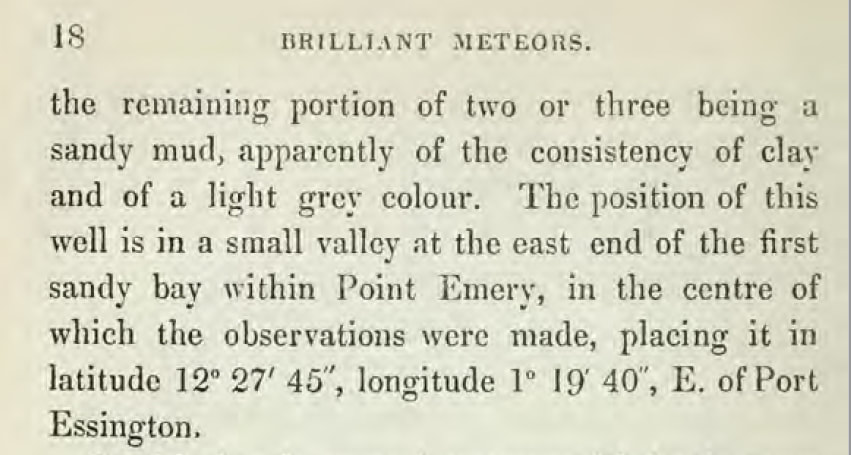
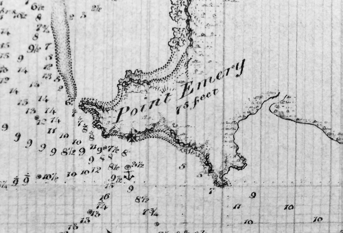
Disc in Australia Vol II p18 Emery's Well
|
|
|
|