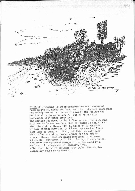
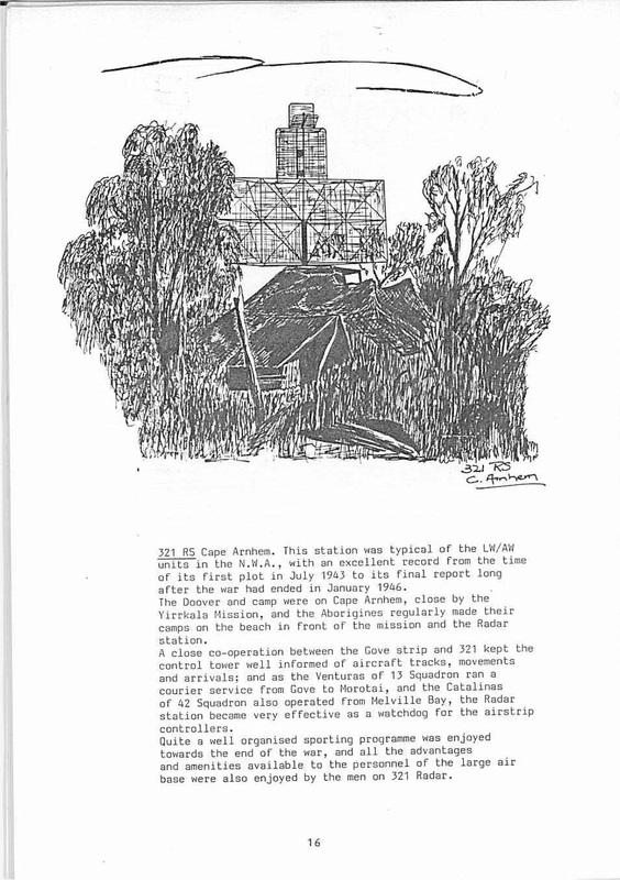
RAAF Radar Station 312RS Wessel Island - Location Unknown
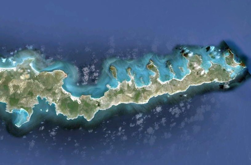
This Google Earth image shows the top end of Marchinbar Island. During WWII it was called Wessel Island. The large bay on the top (western) side is Jensen Bay named by Wyndham Richardson for Petty Officer Jack (Winston John) Jensen who was the resident RAN {SIS} Coastwatcher operating a W/T (Wireless telegraphy) listening post. Jensen returned in the early 1950's as caretaker of the bauxite mine.
There are many tales of Jensen's antics & the handle Mad Jack had some legitimacy. He was also a highly intelligent & well educated man, who lived & worked with Yolngu people for many years. He was described by Beaufort pilot, Len Gairns, as sporting a long flowing beard and dancing up & down like a Mad Moses to alert them to his beach sign giving directions to the survivors of the wreck of HMAS Patricia Cam - on the lonely beach on Garurra Island - where casualties of the Japanese action, Stoker Percy Cameron & passenger Gitjbapuy Marrkulu, lie to this day in adjacent grave that were lost for 70 years.
The location of the radar station remains a mystery although new information & mapping form descendants of servicemen has recently come to light and resolves previous anomalies. The location of the doover, mess and camp are the key to locating the precise spot where, in 1944, radar operator Morry Isenberg discovered the Ancient African coins that are by far the oldest foreign artefacts ever to have been found in Australia.
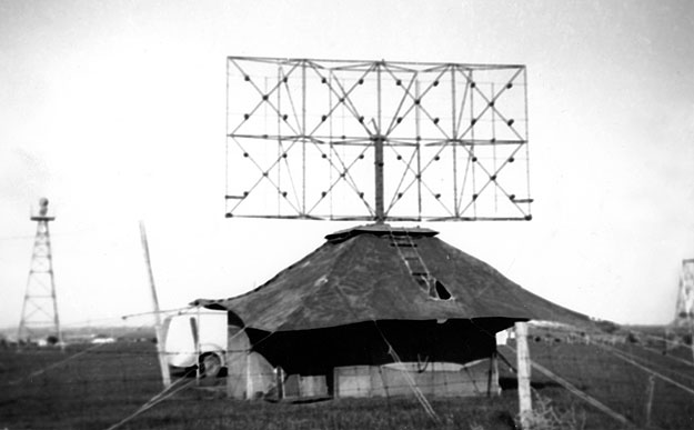
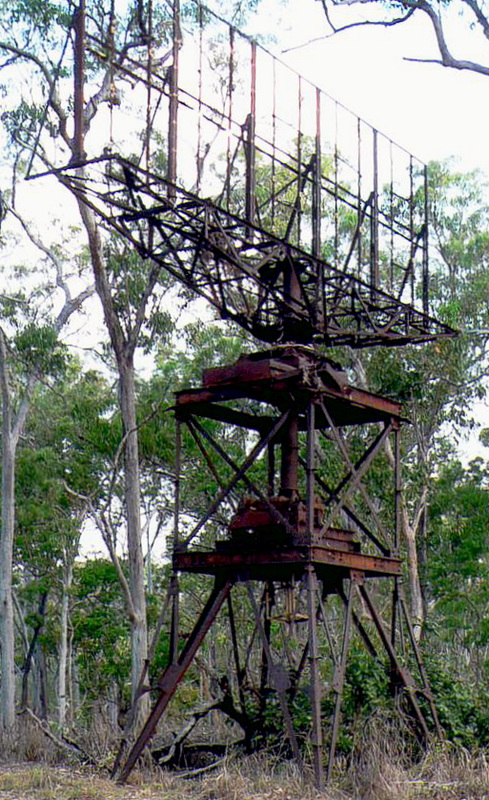
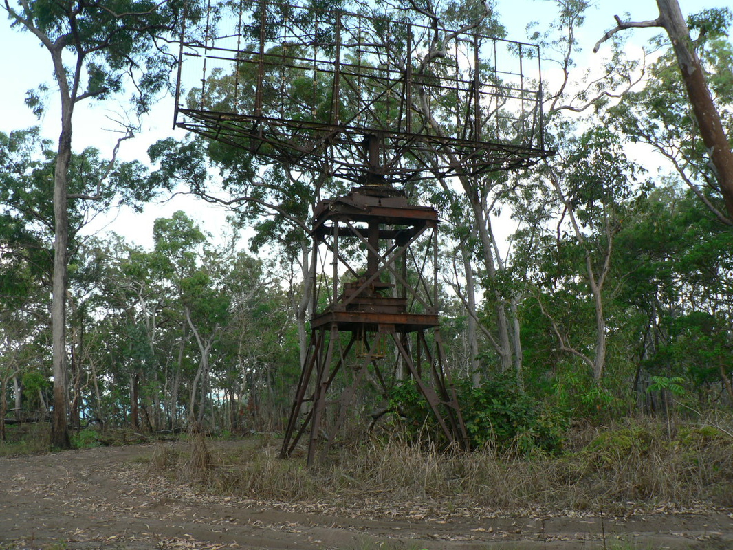
Light Weight/Air Warning Radar
The LW/AW
set was developed in 1942 in Australia by the Council for Scientific and
Industrial Research (later CSIRO) Radiophysics Laboratory in response to the
need for a portable air defence radar station that could be readily deployed in
northern Australia, New Guinea and the islands to Australia's north. The sets
were built by the NSW Railways workshops. A total of 56 units were used by the
Australian forces, 60 by the US Army in the Pacific and a further 12 in Burma.
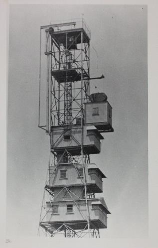
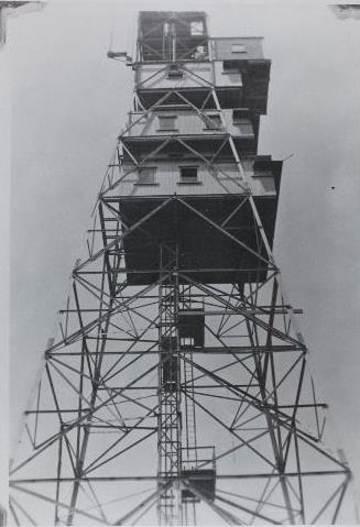
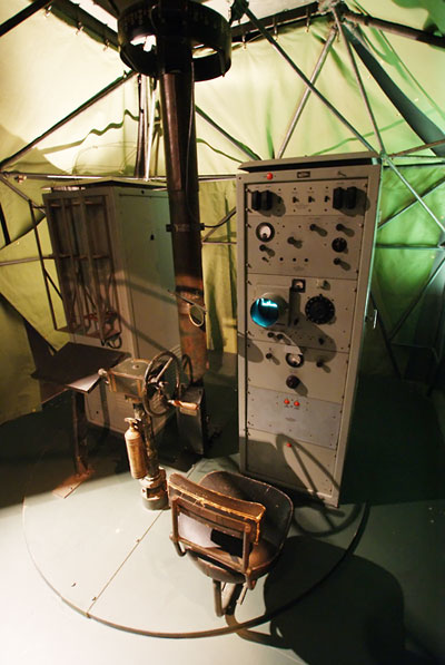
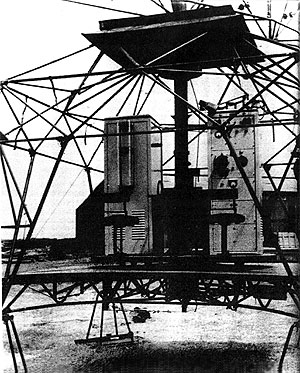
To facilitate portability, the LW/AW set had a hand-turned aerial - the radar equipment and operator were housed in a canvas tent and the photos on this page show the internal layout. The operator, transmitting equipment and antenna all sat on a rotating platform which the operator turned by hand, thus changing the direction of view of the set. The operator's display was a small cathode-ray tube 'A-scope' (range-only display). The physical orientation of the antenna, read off a bearing scale at the top of the antenna shaft, gave the direction of target returns.
One advantage of this method of operation for air defence purposes was that the radar could either be used in search mode, by scanning back and forth through an arc or all around, or in track mode by continuously 'looking' at a particular return of interest, or in a combination of both modes.
|
Diary from Radar Returns
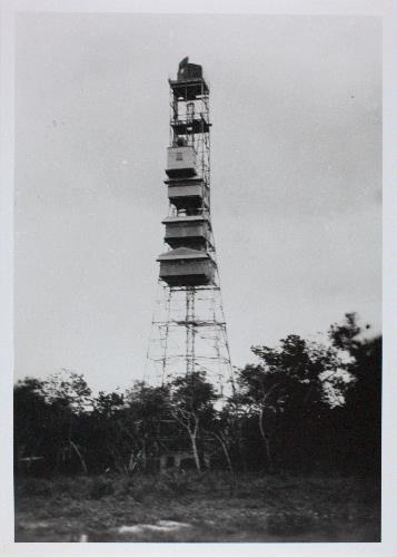
21-04-1943 Equipment loaded on S.S. Islander 22-04-1943 Unit departs 23-04-1943 Unit arrives at Wessel Is. Unloading commenced 15-05-1943 Radar operational 23-07-1944 Tower for radar commenced 11-08-1944 Radar tower completed 15-08-1944 Operations ceased - radar moved to tower 16-08-1944 Operations recommenced from tower 21-01-1945 Unit arrives at Thursday Is. - Equip unloaded 31-01-1945 Unit arrives in Darwin for move south 02-02-1945 Unit leaves Darwin NT |
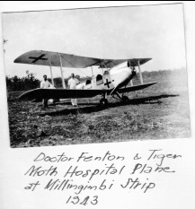
Richardson passed through Milingimbi on his first visit by air. On his return by sea he was caught up in the Japanese bombing and the sinking of the Maroubra which had been towed out from Darwin to assist in the unloading of stores for the rapidly growing air force base. There's a shot of the Maroubra on fire in the gallery below & more about her on our Milingimbi website page.
|
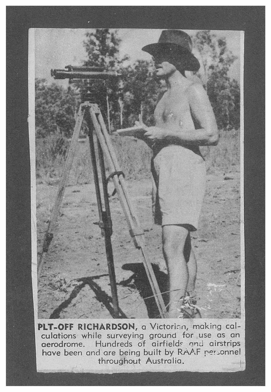
RAAF Surveyor Wyndham Richardson's Story
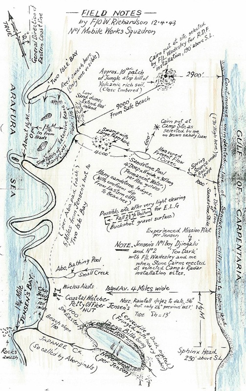
This field map was drawn by Pilot
Officer Wyndham Richardson who flew to Jensen Bay on Marchinbar Island in April
1943 to survey the sites for an RAAF radar doover & camp.
‘My first visit to North Wessel Island early in April 1943 was in the course of two exploratory flights over East Arnhem Land (from Millingimbi Air Strip as base) for the purpose of finding the most suitable site in that area for a coastal radar installation, my duty being to survey and report on features and resources of any sites found scientifically suitable by F/Lt. Wadesley of 44 Radio Wing, for what was to be No.312 Radar Station.
A month later, although I had no foreknowledge of this at the time of my first visit, I was to return to the chosen site in charge of a detachment of men from No.1 Mobile Works Squadron to construct the necessary facilities.
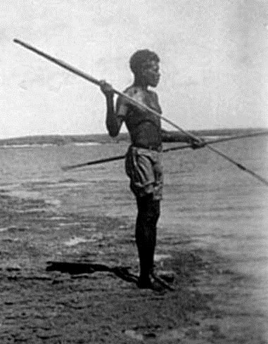
In April 1943, I felt that only a meagre minority of ‘booted' {non-indigenous} Australians beside ourselves had explored this well-nigh northernmost extremity of our Continent. As for Jensen, he walked barefooted and extinguished his cigarette butts by standing on one leg, raising the other heel and rubbing the smouldering stub against it. The only evidence I was to see on this island of earlier visitors was the small sheet iron hut and wireless aerial erected by the Navy to house this solitary Coastal Watcher, who kept radio contact twice a day with Darwin.
Wadesley and I leave with No.1 Boy, "Djingalu ' and No.2 Boy ''Too Dark" to explore a likely area north of Jensen's Hut, as earlier sighted from the plane. Found suitable sites for both radar installation and camp for personnel at five miles northerly from Jensen's hut, and only about a mile northerly from a good landing beach within a wide bay which I named "Two Isle Bay". Erected stone cairns at the respective sites. Elevation for site for "Doover" measured 190ft. above H.W. mark of sea and lay within a 10 acre patch of jungle. I named this hilltop "Green Ant Hill". (Green ants had swarmed over us as I supported Wadesley in a tree limb to enable him to see the horizon, take readings and conduct calculations with his slide rule.)’
‘My first visit to North Wessel Island early in April 1943 was in the course of two exploratory flights over East Arnhem Land (from Millingimbi Air Strip as base) for the purpose of finding the most suitable site in that area for a coastal radar installation, my duty being to survey and report on features and resources of any sites found scientifically suitable by F/Lt. Wadesley of 44 Radio Wing, for what was to be No.312 Radar Station.
A month later, although I had no foreknowledge of this at the time of my first visit, I was to return to the chosen site in charge of a detachment of men from No.1 Mobile Works Squadron to construct the necessary facilities.
In April 1943, I felt that only a meagre minority of ‘booted' {non-indigenous} Australians beside ourselves had explored this well-nigh northernmost extremity of our Continent. As for Jensen, he walked barefooted and extinguished his cigarette butts by standing on one leg, raising the other heel and rubbing the smouldering stub against it. The only evidence I was to see on this island of earlier visitors was the small sheet iron hut and wireless aerial erected by the Navy to house this solitary Coastal Watcher, who kept radio contact twice a day with Darwin.
Wadesley and I leave with No.1 Boy, "Djingalu ' and No.2 Boy ''Too Dark" to explore a likely area north of Jensen's Hut, as earlier sighted from the plane. Found suitable sites for both radar installation and camp for personnel at five miles northerly from Jensen's hut, and only about a mile northerly from a good landing beach within a wide bay which I named "Two Isle Bay". Erected stone cairns at the respective sites. Elevation for site for "Doover" measured 190ft. above H.W. mark of sea and lay within a 10 acre patch of jungle. I named this hilltop "Green Ant Hill". (Green ants had swarmed over us as I supported Wadesley in a tree limb to enable him to see the horizon, take readings and conduct calculations with his slide rule.)’
|
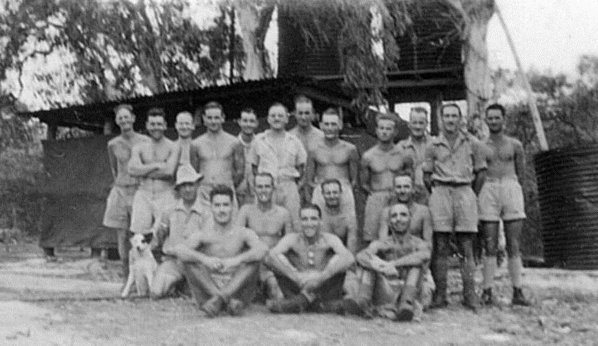
This image was taken by Wyndham Richardson who surveyed the radar doover & camp sites and returned to construct the camp in mid 1943. His daughter has kindly allowed access to his papers. If anyone has further information or would like a copy of the image please let us know. There was a high level of secrecy concerning radar activity and records are hard to find. This secrecy is especially prevalent in the coast watch operations which were under the Secret Intelligence Service and whose records moved north with Macarthur's HQ after the privations of downtown Melbourne. Coastwatchers included civilians such as missionary Thornell at Yirrkala. Much of the material on this page has been supplied courtesy of Wyndham Richardson's daughter Ann Brothers, Prof. Bennett's daughter Jane Bennett - radar historians & devotees Ian McKellar, Alex Culvenor and Steve Allan of the Office of Air Force History at Fairbairn in Canberra.
| ||||
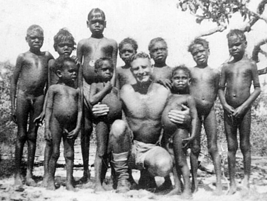 CE Hoffman with Yolngu boys near Jensen Bay in 1943 the medal may be a Darwin pass.
In the attached photo, taken 2nd June 1943 by Wyndham Richardson of CE Hoffman with the local gang the image is annotated Swivel Eye 5th from left at back & at right is Snowball. Jane Bennett has worked with the families to add the following - 'it shows the tall boy with medallion is Mingyi. To his right (second in from left) is Balilbalil and next to him on the far left is Thapa. On the far right is Malawa's father (number 2 Malawa). Second in from right is a girl that James (Djingulul's son) thought might be Rosie, his eldest sister, now deceased. Given the dates, I think it is more likely to be Mary, his mother and Gamaritj's older sister, but I didn't test this thinking with Gamaritj.
The maker of our dilly bag, Djingulul's first wife (his brother's widow), known to us as Natalie, a mission girl from Yirrkala, is known to people at Galiwin'ku as Ngatili. Her father is Liapan, whose brothers are Dhunggala and Djoniwuy. I think Ngatali's family might also have been Djarrwalawal and Ganbaltji though by this time I had lost track of the relationship. Garrudju (Jane) was well across all this.'
The maker of our dilly bag, Djingulul's first wife (his brother's widow), known to us as Natalie, a mission girl from Yirrkala, is known to people at Galiwin'ku as Ngatili. Her father is Liapan, whose brothers are Dhunggala and Djoniwuy. I think Ngatali's family might also have been Djarrwalawal and Ganbaltji though by this time I had lost track of the relationship. Garrudju (Jane) was well across all this.'
Some Top End Radar Stations