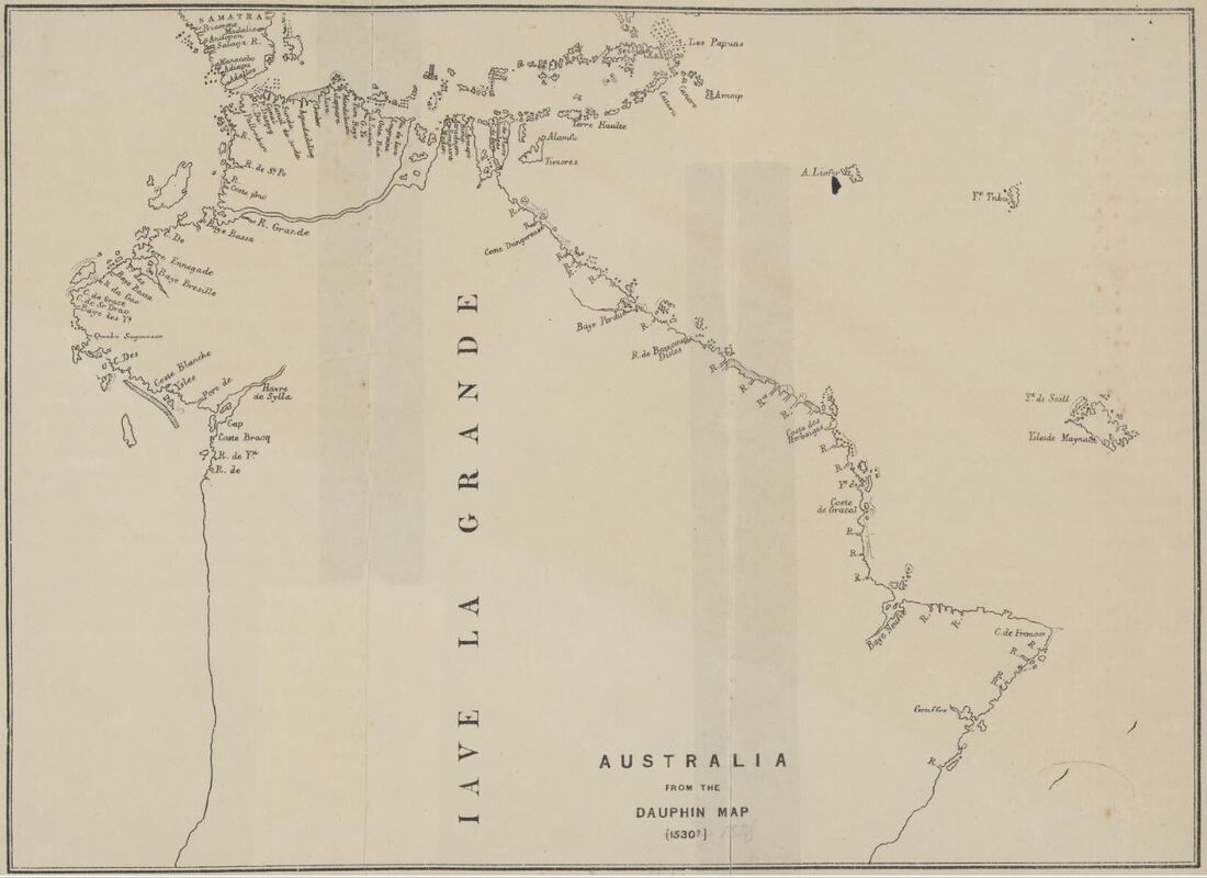
JAVE LA GRANDE
How South America became Australia
It is said that Portuguese Maps do not generally survive because:- they were politically sensitive, only held at Lisbon - economically valuable & so closely guarded State Secrets or lost in the 1755 'All Saints Day' earthquake - tidal wave & fire storm which destroyed the Royal Archives & most of Lisbon. Spanish mapping fared better although, until comparatively recently, there was little available in English.
The maps herein are considered in respect of their relevance to the early European presence in SE Asian waters and early contact with Australia - either directly or through their agents. There are neither conspiracies nor arcane formulae - just normal human frailty in the struggle to engagingly represent a globular blue-green planet - on a not very flat strip of parchment - with floating crusts of similarly shaped land - appearing at various times and with varying degrees of reliability - upon vast expanses of wet & wobbly nothingness. A Renaissance Story of Discovery - Borne of Hope, Raised on Greed & Orphaned by Reality.
The maps herein are considered in respect of their relevance to the early European presence in SE Asian waters and early contact with Australia - either directly or through their agents. There are neither conspiracies nor arcane formulae - just normal human frailty in the struggle to engagingly represent a globular blue-green planet - on a not very flat strip of parchment - with floating crusts of similarly shaped land - appearing at various times and with varying degrees of reliability - upon vast expanses of wet & wobbly nothingness. A Renaissance Story of Discovery - Borne of Hope, Raised on Greed & Orphaned by Reality.
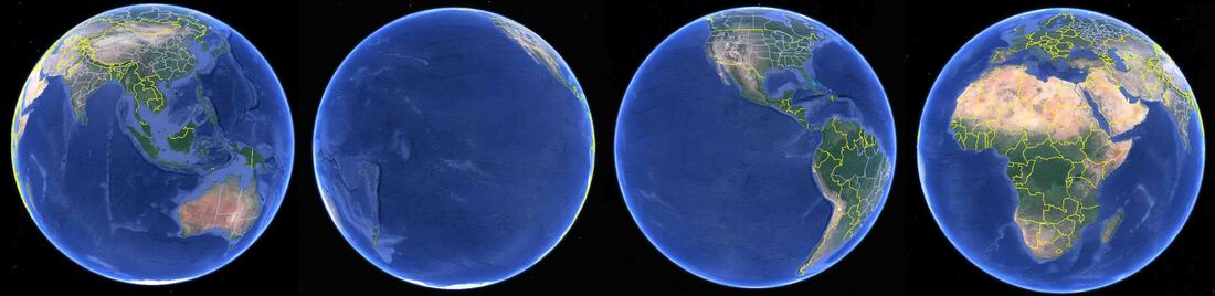
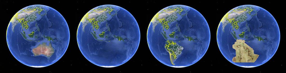
The middle - the Pacific & the Americas - had to be wedged between Europe & the Orient - doubling the size of Google Earth
Confounding: - The absence of accurate chronometers prevented the calculation of Longitude whilst at sea. Most map makers were portrait or landscape artists. The explorers were seamen navigators not surveyors - lacking the time, skills and equipment to produce accurate charts.
Good plain useful maps are embellished to impress gullible purchasers, unwary institutions & those acquiring kudos with other people's money. Some maps are just plain forgeries, others have the date altered or material added. One has been torn to make it appear as though a signature embayment on the north end of Papua was mapped when it was not. Some few, like the Bonaparte Map, are a palimpsest of such bewildering ineptitude as to only be displayed by someone beyond criticism - e.g. uncle owns a guillotine {even that was copied from the Halifax original}.
Bias:- Columbus believed to his dying day that he had sailed to the East Indies and his brother, a map maker at Lisbon, would have supported his sibling & the wealthy patrons of the voyages westwards. The name of the actual map maker is not recorded. Such a desirable discovery would be hard to dispel not least for the map makers who looked across the Atlantic - not to the coast of China - but to an entirely new world of North and South America. Beyond that lies the empty vastness of the Pacific Ocean. A wedge 9,000 miles long and 13,000 miles wide - more than half the planet.
There were many powerful groups wedded to the notion of a great south land being necessary to balance all the land in the northern hemisphere. Once a feature made it onto the maps it was hard to shake - it took the Pope to finally put a stop to the 'Island of California' and Papa intervention shifted the line between the Spanish & Portuguese hemispheres.
For the artists map makers, the imbalance of the scheme created by such a void as the Pacific Ocean was unacceptable. In the end, artistic licence was spared much of the void by simply bumping the early wedge of South America under the Portuguese mapping of the tops of the islands running from Sumatra to Papua New Guinea. With the Spices rich Orient in the East and the Americas in the West - the Pacific Ocean was off the Mappa Mundi.
The Harleian 1547c version of the Dauphin shows the mapping solution - shunt the old South America under Java & the Pacific goes round the back.
The Magellan Expedition - Juan Sebastian Elcano brought home to Spain the two remain ships of five that set out and the surviving 18 Europeans in 1522. They managed to bring with them a small amount of spices which alone paid for the expedition, the lost ships and much more besides. Magellan was long dead but got the glory - Elcano was on the next ship out to grasp the unimaginable wealth of the Spice Islands - instead meeting his death.
Background
|
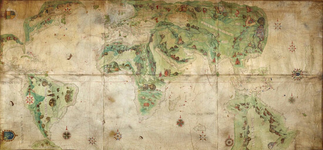
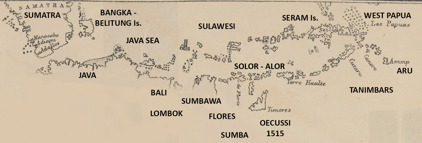
This page seeks to show how South America became Australia and how along the way some Portuguese & Spanish mapping survives - preserved within the stream of subsequent discoveries. The Spanish pushed westwards to the Indies whilst the Portuguese opened passage eastwards via India and Sumatra. The first is the map of Columbus's 1492 voyage to the Americas which gives us the oddly pointed South America landform. Upon it will be stuck the Portuguese mapping of the passage to the East Indies via the Cape of Good Hope & India - through the Sunda Strait between Sumatra & Java and eastwards through the Java, Sunda & Banda Seas. They charted only what they saw - as a coastal mariners guide - the top side of the islands to the south and the bottom coast of the islands to the north - Sulawesi, Ambon & Seram/Ceram - with all the resident hazards to navigation.
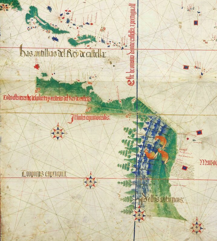
It is suggested that when it became necessary to wedge North & South America and the Pacific Ocean into the existing Mappa Mundi scheme - the oddly shaped & incomplete South America was simply shunted around to join onto the bottom of Java & the others of the Solor Archipelago whose southern coasts had not been charted. The Caribbean coast of Venezuela does bear some similarities to Java and north Australia but Brazil's easterly beak is a stand out. |
Detail Columbus 1492 voyage
|
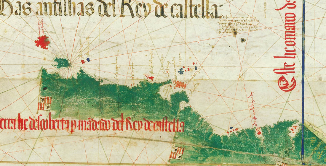
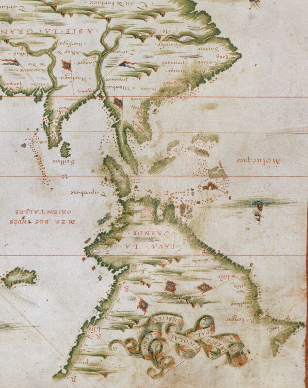
The tip of the Dauphin Map - showing the Portuguese mapping.
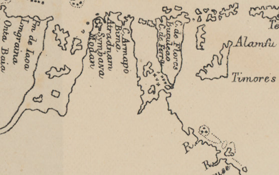
North coasts of Java, Flores + Timor et al
|
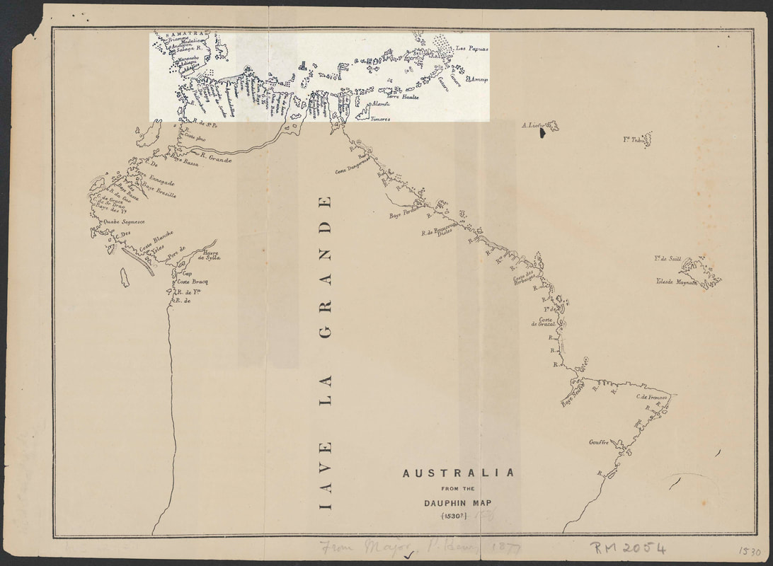
The Dauphin c1530 - Portuguese mapping stapled onto a surplus landmass ex South America
|
THE SPANISH - Westwards to the Orient
Columbus 1492
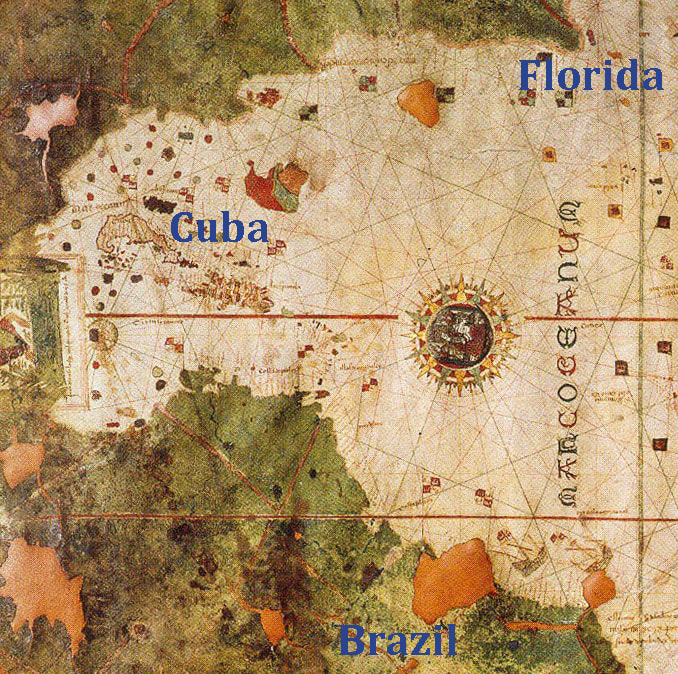
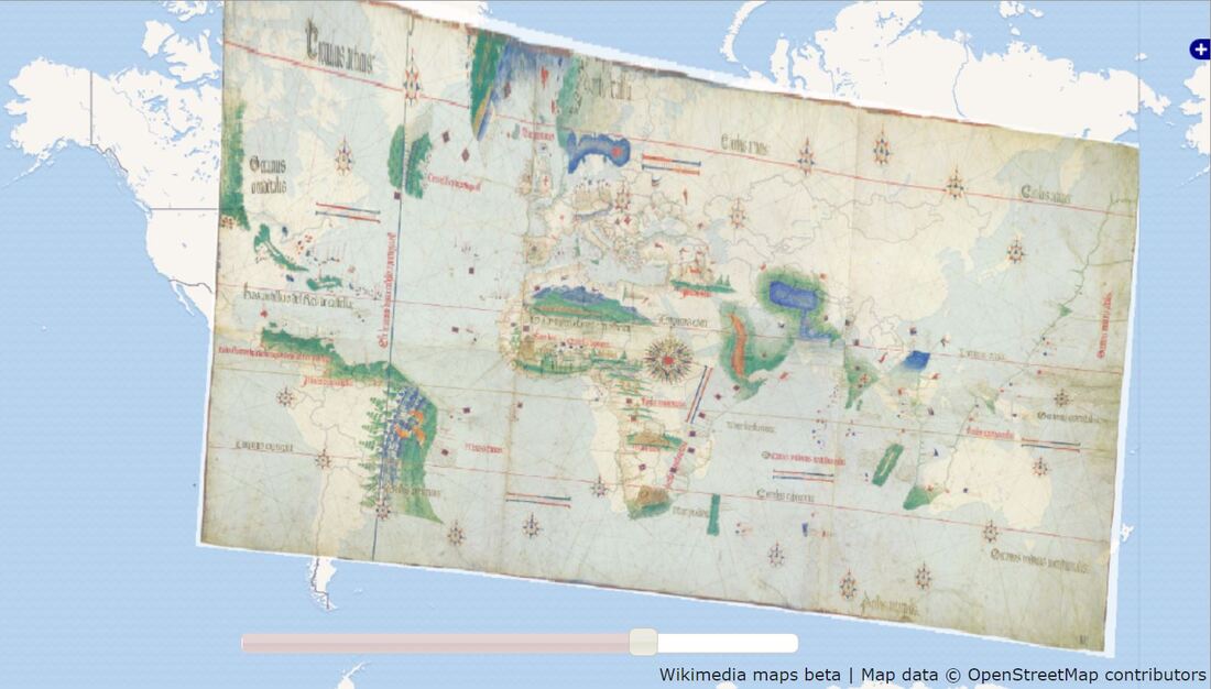
This Spanish map of 1500 attributed to Juan de la Cosa shows the 1492 voyage of discovery of America by the Italian explorer, Christopher Columbus, whilst in the employ of the King of Spain. Aside from the date, authorship & may other issues {discussed eloquently in the pdf below} this early map is interesting in that it shows the New World at left in a much larger scale than the Old World at right. Cuba and Haiti (Hispaniola) appear below a substantial land mass and above the coast of what is now know to be South America - populated by Red Macaws. Cuba & the Bahamas above South America are fairly represented to scale but the south coast of the USA fares less well. Florida is way out on another scale perhaps indicating the later voyages. The map names the owner of the Santa Maria as the major benefactor but authorship is unknown - the coincidental presence of Lisbon mapmaker Bartholomew Columbus - Christopher's younger brother - is persuasive. The only way to vindicate C. Columbus's claim is if Cuba & Hispaniola abut Sumatra.
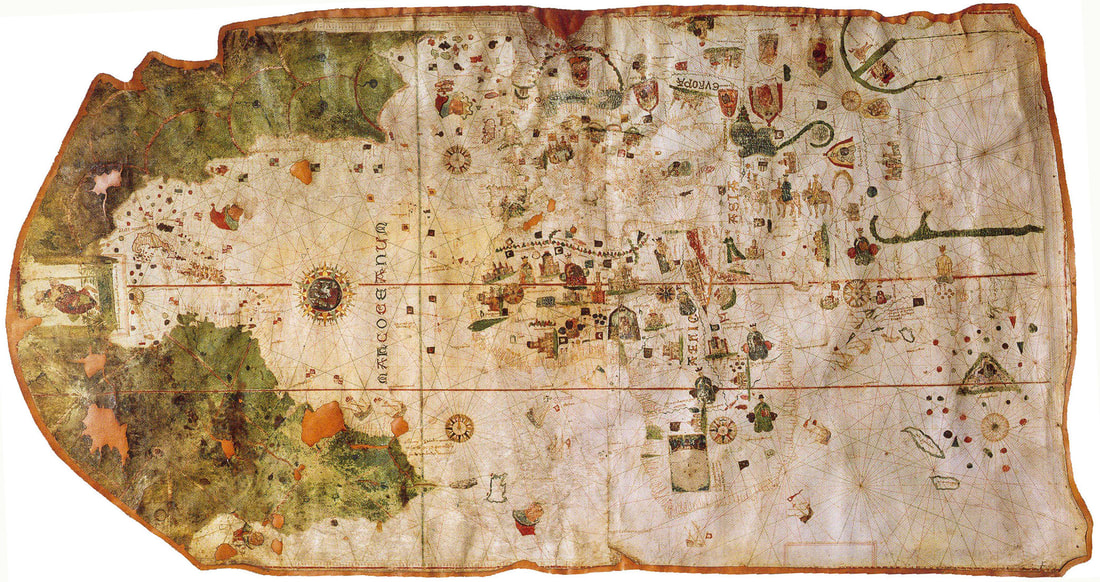
Columbus 1492 1st voyage by Juan de la Cosa c1500 - Sth. America at 8 o'clock - 9 o'clock Caribbean & Cuba - 10 o'clock Texas & 11 o'clock Florida
| 305-la-cosa_1492_map__1500_.pdf |
There were immense problems facing cartographers at this time when the basic continental landforms were still emerging. This becomes apparent when New World map data needs to be wrestled into a single scale 'Mappa Mundi' {Map of the World} as in the Portuguese Cantino Map below. Curiously Columbus' brother, Bartholomew, was a mapmaker in Lisbon in 1479 - yet the map is attributed to de la Cosa who was the owner of Columbus' Flag Ship 'Santa Maria' and was on the first voyage.
THE PORTUGUESE - Eastward to the Orient
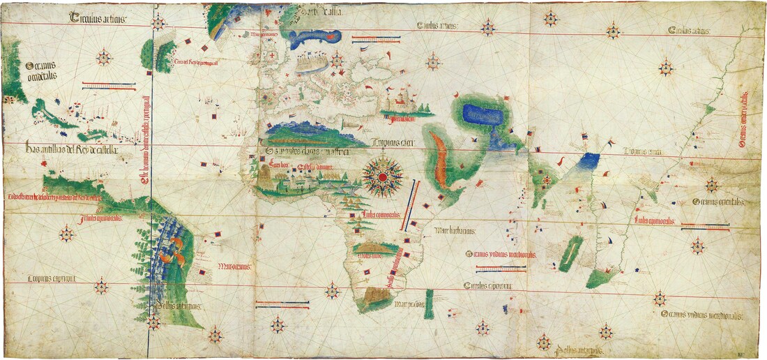
The Cantino Planisphere 1502
This work by an unknown cartographer depicts Portuguese knowledge at 1502. The Oceanus Occidentalis at extreme left and right is the fabled Orient - the East Indies - that Colombus believed, to his dying day, that he had reached. The Portuguese were opening their trade routes around Africa via India to the Indies whilst the Spanish looked westwards to the same goal and direct access to the producers unfettered by middlemen.
|
The Cantino Map presumably includes the voyages of Vasco De Garma to India and Columbus to the Bahamas which he believed to be the East Indies so that Cuba & Hispaniola at top left, instead of abutting Florida become Java & Sumbawa abutting Sumatra across the Sunda Strait. Cartographers faced the immense task of inserting the Americas and the Pacific between Europe and the Orient. The similarity of the critical islands of Java & Cuba being approached from the West and East respectively and both considered gateways to the Orient was bound to cause confusion.
The shape of the north & east coast of South America appears again in the Dieppe Maps as the Great South Land - Jave La Grande and in the 'Vallard' rendition is reinvented as Australia. The map at right shows Cuba & Hispaniola (Haiti) - Florida & the Bahamas - San Salvador (previously Watling Island) was renamed in 1925 in the belief that this is where Columbus made landfall. The confusion was contagious. |
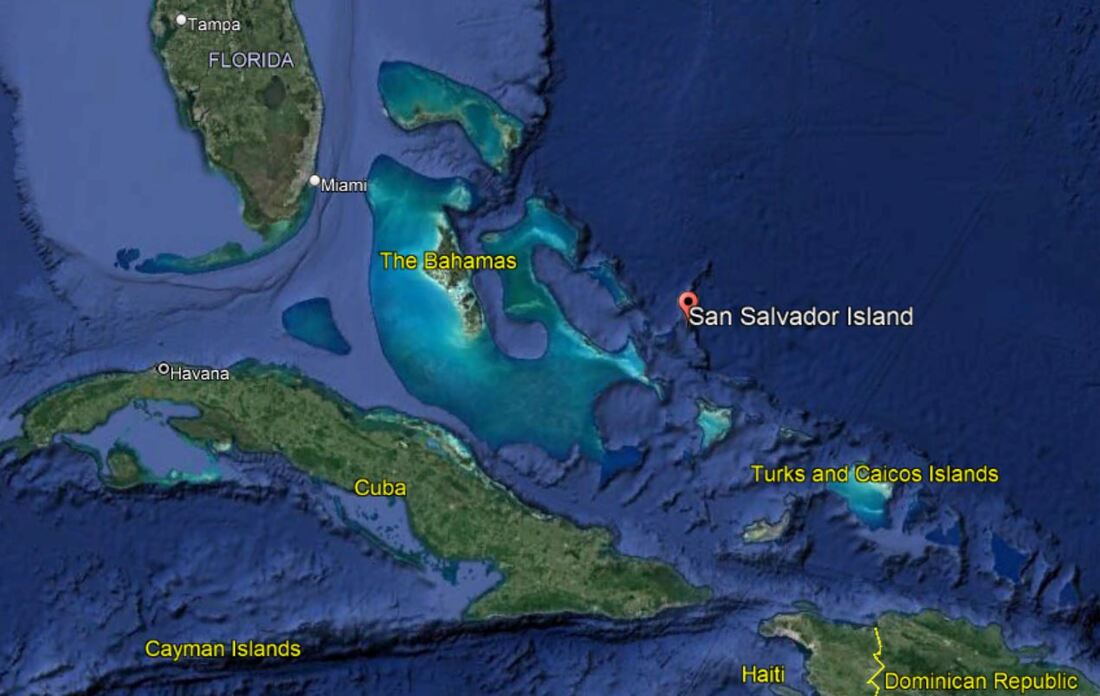
Google Earth - San Salvador
|
Cuba & Hispaniola - Venezuela - Brazil & Red Macaws
|
Google Earth - South America minus Red Macaws
|
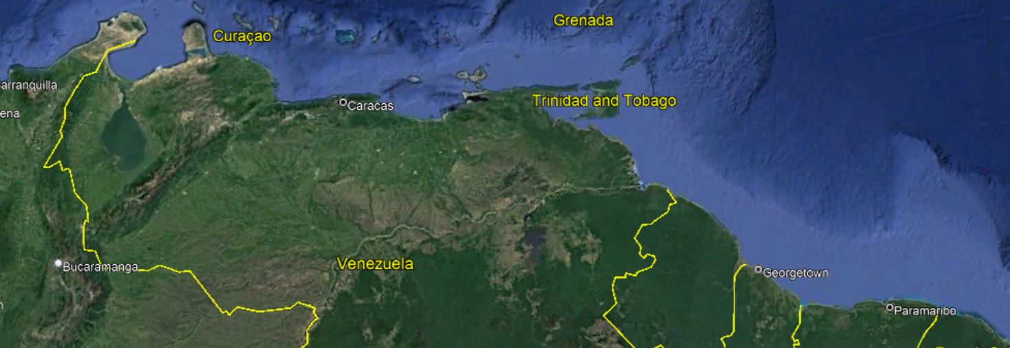
Venezuela north coast - Google Earth
|
The North or Caribbean Coast of Venezuela
|
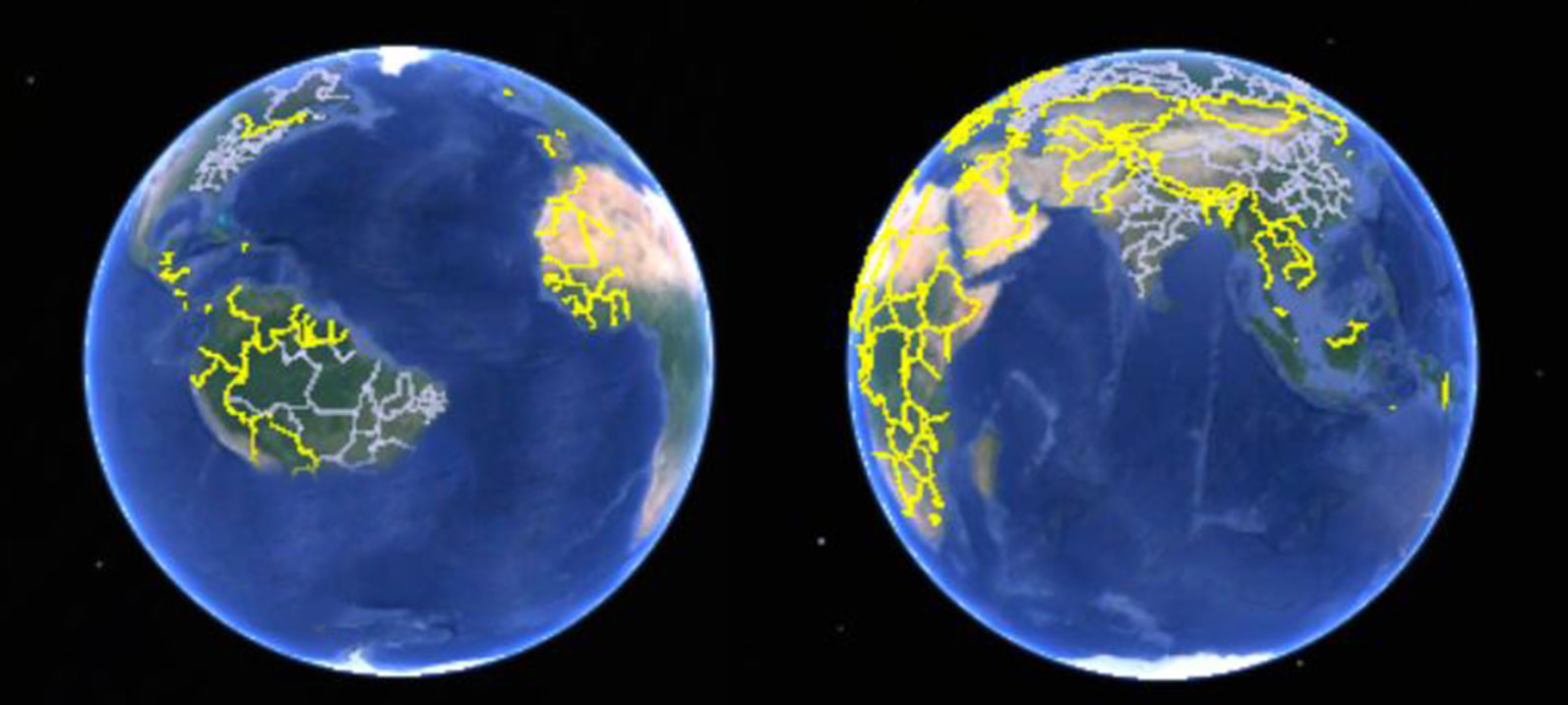
The Google Earth world of the year 1500 before the Harleian Dauphin Map
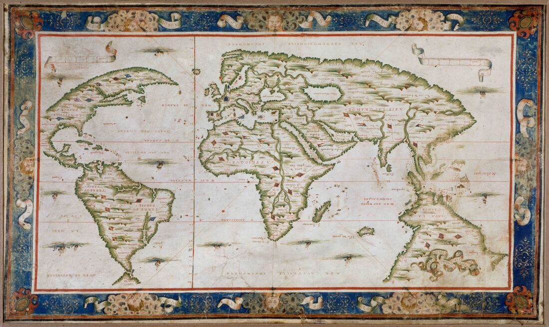
The Harleian or Dauphin Map c1547
"Produced in the northern French port of Dieppe, the Harleian or Dauphin map was prepared during the reign of Francois I of France (1515-1547) for his son, the Dauphin. Along with the Rotz atlas, presented to Henry VIII and also exhibited in Mapping Our World, it was one of several maps that have fuelled speculation about a continent resembling Australia, apparently charted by the Portuguese in the early 1500s and recorded by the map-makers of Dieppe. The Harleian map's most outstanding feature, a huge landmass south of Indonesia, is named ''Iave (Jave) la Grande''. SMH
Norman or Dieppe School Desliens 1566 - Library of Congress - inverted
Australia Incognita - space filled by shunting South America under Java to join Sumatra across the Sunda Strait - west of Java - not east.
Transposition
|
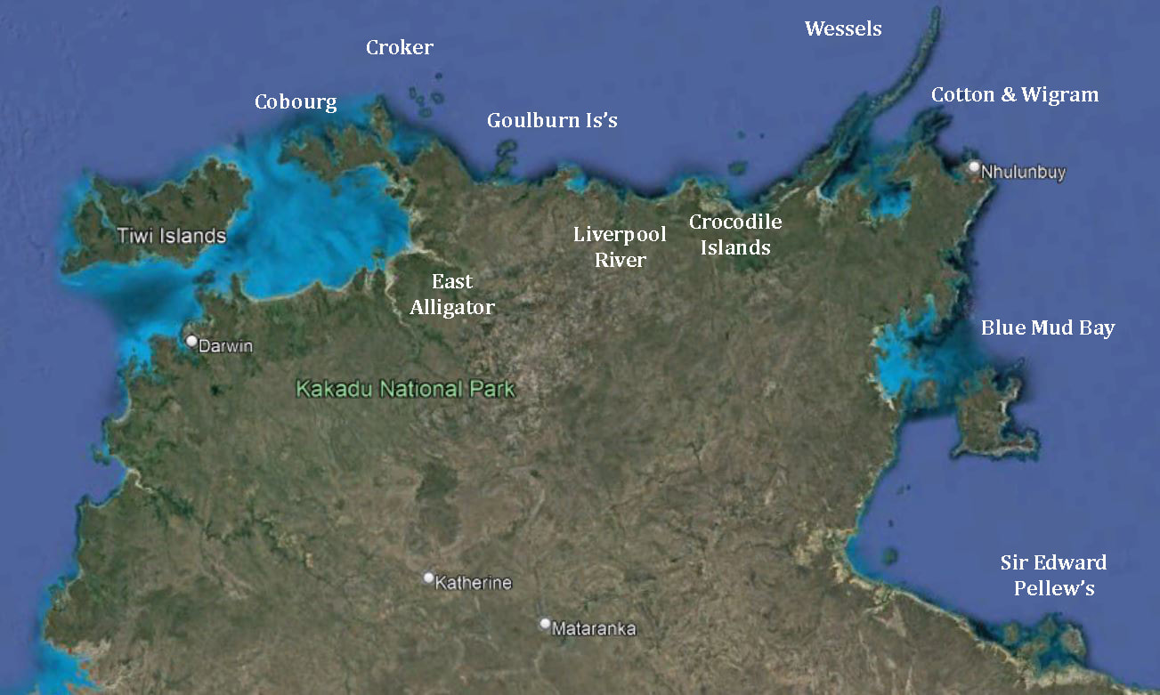
Google Earth - Top End
|
Sunda Strait to the East Indies from the Harleian Dauphin Map
Extract from the Dauphin Harleian Map 1530c
|
Desliens Portolan 1566
|
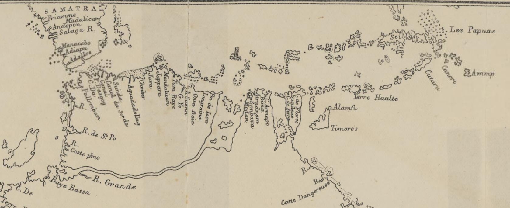
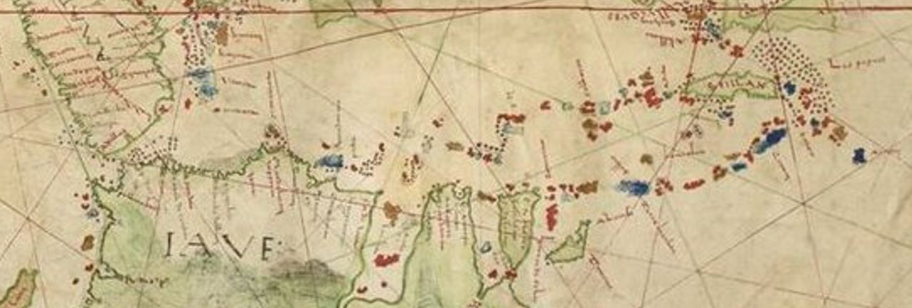
The top of the Dauphin Map from Samatra - Java - Flores - Timores and Les Papuas supposedly on the north coast of Australia
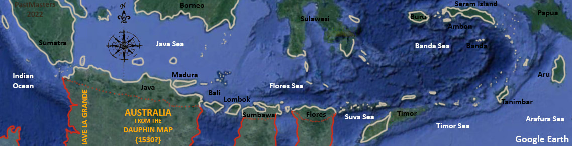
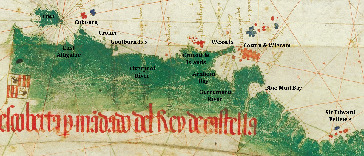
The Portuguese mapping of coasts and shoals from Sumatra to Papua New Guinea - overlaid onto the Dauphin Map
Jave La Grande - Land of the Jumblies
Australia was unknown & far away - the Tiwi Island of Australia's Top End Coast are almost 3,000kms east of the Sunda Strait - the same distance as South America is from Africa. Australia does not emerge even as speculation until the eastern coast is discovered by Cook on the 1770 voyage & the Vallard Map is unsuccessfully marketed to the British Museum as the pre-Cook 'first map of Australia'. The similarities of coastal features are the result of similar natural forces upon similar geology plus Observer Bias - as the eye of faith which sees faces in the flames - which is another such natural force at mischievous play.
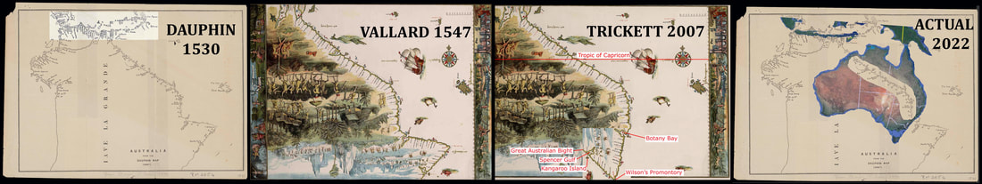 The transition of South America to Australia
Other follies are preserved - the decomposing mattress of an island off the 'Queensland' coast and the provocatively shaped major river estuaries. However, the star survivor is the startlingly sharp eastern point which, in a recent descent into the preposterous, becomes unhinged & pivots to form Wilson's promontory. For 500 years the search has been on for a home for the displaced counterbalance continent that once cupped the Caribbean Sea to the lips of the Orient. It stoically resists reality because - like a Monty Python Pet Conversion - all you need to do is:- 'strip the fur - stick on a couple of wings and staple on a beak of your own choice'....beautiful plumage the Red Macaw.
|
And each of them said, "How wise we are! Though the sky be dark, and the voyage be long, Yet we never can think we were rash or wrong, While round in our Sieve we spin!" Far and few, far and few, Are the lands where the Jumblies live; Their heads are green, and their hands are blue, And they went to sea in a Sieve. (The Jumblies - Edward Lear) |
The Vallard 1547 1st 'Map of Australia'?
|