TOP END TIMELINE
This page seeks to draw a timeline for the Top End of the Northern Territory of Australia. A simple chronology of major geological & climatic events which predicate the movement of people into Australia. Where possible graphic examples of cyclical geomorphological processes will be included.
The Last Ice Age (22kya - [18kya] - 12kya)

Tim Stone at Galiwin'ku Quarry indicating band of pliestocene sand.
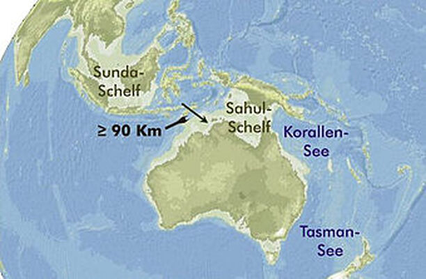
The last Ice Age, starting some 22k years ago, was incredibly dry. Sea levels ~ 150m below today & the coast 150km north, our 'Australia' a vast desert of fine red Centralian sand dunes (now mined as builders' sand) from the Great Australian Bight up past the land-bridge into Papua New Guinea. As the relative sea level rose & regular rainfall returned - the few thousand family groups that had spread out thinly along the creeks and coastal fringe far to the north now faced the rising sea level which cut off New Guinea that flooded the Carpentaria plains & began to build the floodplains some 4k years ago. Because of the odd nature of the Gulf Country, people & their dingos were able to move deep inland following the rivers down through the Channel Country into the heart of Australia.
Recent research shows the Kimberly area experienced a 1500 year drought between 5k & 4kya (source ABP)
Recent research shows the Kimberly area experienced a 1500 year drought between 5k & 4kya (source ABP)
SNAPSHOT - Northern Territory
- 4 Thousand Years Ago (kya) Floodplains formed - Dingos arrived
- 7kya - Beaches around Darwin & Top End began to form.
- 8kya Sea level stabilises at current height
- 16kya Glaciers and ice caps begin to melt flooding continental shelves with sea water
- 18kya Extreme point of last Ice Age - Glacial Maximum i.e. furthest extent of the ice. Sea level 120metres lower - coast 150kms north of Darwin
- 26kya Climatic conditions begin to deteriorate again as descent into the Last Ice Age begins
- 39kya Climatic conditions begin to warm again after which few, if any, megafauna remain
- 45kya Climatic conditions begin to chill again – opportunity for humans to reach Australia coincidental with megafaunal extinctions
- 60kya Climatic conditions warm - Lake Eyre full
- 75kya Climatic conditions begin to chill - opportunity for humans to reach Australia coincidental with megafaunal extinctions
- 130kya Last time sea levels close to current height [slightly higher then]
- 190kya Glacial Maximum - opportunity for humans to reach Australia
Terms & Abbreviations
Billion - A thousand million years.
BYA - Billion Years Ago also known as GYA - God alone knows how many Years Ago.
Ice Ages - are periods of extreme cold occurring between 2.4mya to 11,500mya.
Glacials - are the cold periods and the warm periods are Inter-glacials.
Glacial Maximum is the height of the Ice Age when the ice is of greatest extent - sea level lowest - land is driest.
KYA - Thousand Years Ago
Statials - Cold periods
Interstatials - Warm Periods
Planet Earth States (NS) https://www.newscientist.com/article/dn18949-the-history-of-ice-on-earth/
Greenhouse Earth - Tropical temperatures extend to the Poles & no ice sheets.
Icehouse Earth - Some permanent ice - the extent of which varies greatly.
Snowball Earth - Ice covers entire planet.
Icehouse Earth - Some permanent ice - the extent of which varies greatly.
Snowball Earth - Ice covers entire planet.
TIMELINE
- 4.8bya - Planet Earth formed
- 3.2bya - Magma Chamber solidified on South Adelaide River Floodplain. (2.3 billion years) the oldest exposed rock in the NT.
- 2.4bya - HURONIAN ICE AGE begins. (2.4 billion years ago also 2.4Gya) during the Siderian & Rhyacian Periods of the Paleoproterozoic Era.
Also known as the Huronian or Makganyene Glaciation - it was the earliest and longest Ice Age. It was precipitated by the Great Oxygenation Event (GOE) which increased Oxygen & decreased Methane in the atmosphere. Oxygen & Methane combined to form Carbon Dioxide & Water - which hold less heat.
The first 100 million years was the worst
- 2.4bya to 2.3bya - Snowball World - entire planet covered by ice. This may have caused the 250ma pause in volcanic activity - reducing atmospheric CO2 & reducing the Greenhouse Effect thus prolonging the freeze.
- 2.1bya - HURONIAN ICE AGE ends.
- 850mya - CRYOGENIAN ICE AGE begins. (850 to 630mya NS) 200ma deep freeze - possibly including periods of Snowball Earth.
Glaciation possibly triggered by the evolution of large cells & multicellular organisms falling to the seabed after dying. This would have starved the atmosphere of CO2 so weakening the greenhouse effect and lowering global temperatures. New Scientist
- 750 to 700mya - Sturtian Glaciation
- 660 to 635mya - Varanger or Marinoan Glaciation
- 630mya - CRYOGENIAN ICE AGE ends.
- 550mya - Arnhemland Plateau of sandstone began to form from river silt deposited by one or more major rivers from a mountain range to NW.
540mya NEOPALEOZOIC ERA ends
- 540mya PALEOZOIC ERA begins
- 500mya - Mission Beach on Elcho Island formed (490-547mya)
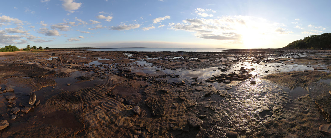
Sunset over 500myo Mission Beach on Elcho Island showing ripple rock & tracks of small sea creatures. Ancient wave action was from the West.
- 490mya to 445mya - ORDOVICIAN PERIOD - most land part of Gondwana Land at the equator - most areas ocean outside the tropics.
- 460mya - ANDEAN-SAHARAN ICE AGE begins. Second largest mass extinction.
- 445mya - ORDOVICIAN PERIOD ends.
- 445mya to 420mya - SILURIAN PERIOD
- 430mya - ANDEAN-SAHARAN ICE AGE ends.
- 420mya - SILURIAN PERIOD ends
- 359mya - KAROO OR LATE PALEOZOIC ICE AGE begins - possibly due to plant growth raising oxygen levels after the Cryogenian Glaciation.NS
- 359-318mya Mississippian Period peak period of ice formation - Glacial Maximum.
- 318-299mya Pennsylvanian Period peak period of ice formation - Glacial Maximum.
- 260mya - KAROO OR LATE PALEOZOIC ICE AGE ends. (251.902mya)
- 250mya Permian Extinction - the most severe.
14mya - Antarctica's southern ice sheet created by an 8 degree drop in temperature caused by the rise of the Himalayas. NS
- 7mya - human ancestors walked upright - between 5 & 7mya.
- 3.2mya Greenland & the Arctic become heavily glaciated. NS
- 2.6mya - PLEISTOCENE EPOCH starts. (2.588mya) Start of the QUATERNARY PERIOD & MESOZOIC ERA
- 2.59mya Quaternary Glaciation starts perhaps caused by fall in CO2 due to Himalayan weathering & changes in Earth's orbit or both. NS
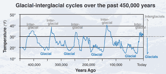
'During “glacial” stages, the temperature was low and ice extended far away from the poles. During “interglacials”, the temperature was somewhat warmer and the ice retreated. Brief, inconclusive periods of advancing ice – typically lasting less than 10,000 years – are called “stadials”; conversely, periods when the ice retreated, but only briefly, are called “interstadials”.'NS
'During the first two-thirds of the Quaternary, the ice advanced and retreated roughly every 41,000 years – the same tempo as the changes in the tilt of Earth’s axis. About a million years ago, the ice switched to a 100,000-year cycle for reasons that were until recently a mystery. Now more detailed information about the timing of the ice’s movements may have helped glaciologists find an answer.
To make matters more complicated still, the ice didn’t advance and retreat simultaneously all around the world. Often it would begin advancing on one continent, with the others only being covered thousands of years later, and then linger on a few continents several millennia after it had disappeared from the others.
So there were actually many overlapping glaciations during the Quatenary, each separately named: the Bavelian and Cromerian complexes of glacials and interglacials; the Elsterian glacial; the Holsteinian interglacial and the Saalian glaciation, among others.' NS
- 2.3mya - Homo Sapiens evolved - earliest flaked stone tools.
- 2mya - humans spread out of Africa.
- 250kya - Woolly Mammoths appeared.
- 190,000ya - Glacial Maximum - opportunity for humans to come into Australia.
- 130 to 114kya Eemian Interglacial saw ice retreat before returning to form what is colloquially known as "the ice age".NS
- 120,000ya - Glacial Maximum - opportunity for humans to come into Australia. The last time sea level near (slightly above) current level.
- 110 to 12kya Our Ice Age NS
- 45,000ya - Glacial Maximum - LATE PALEOZOIC ICE AGE - opportunity for humans to come into Australia.
- 22,000ya - THE QUATERNARY ICE AGE - Start of the latest Ice Age.
- 18,000ya - Last Glacial Maximum (Europe 20mya NS) when sea level at its lowest c130 metres below current levels - 120kms north of Darwin.
- Relict Pleistocene Continental Dunes - such as those in the Simpson Desert today - extended from Northern Tasmania to Southern New Guinea.
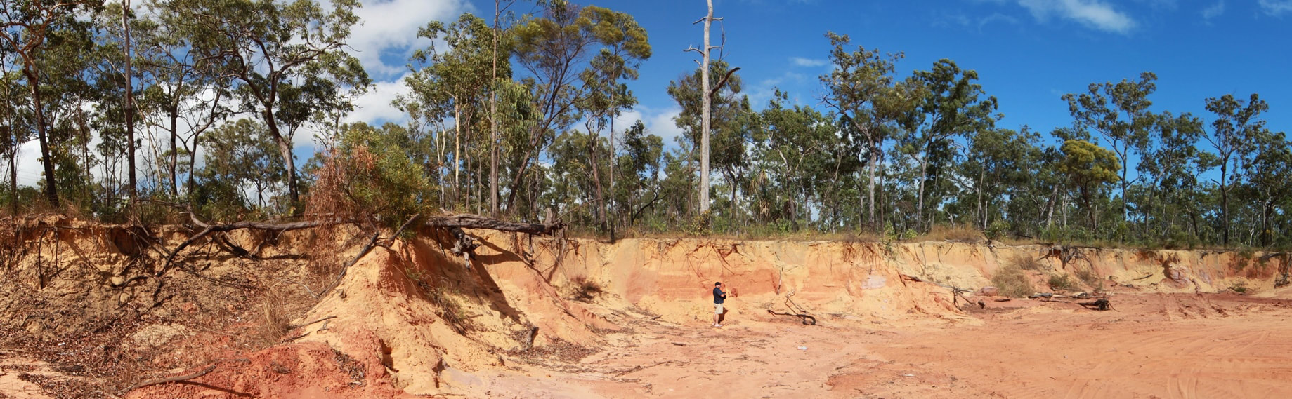
Dr. Tim Stone beside band of red relict Pleistocene Dune - builder's sand - in the Galiwin'ku quarry.
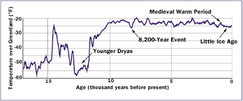
- 14,700 to 13,400ya the Older Dryas Glacial de-forested most of Europe. NS
- 12,800 to 11,500ya the Younger Dryas Glaciation froze Europe for many months shutting down Atlantic 'Conveyor-belt Current' - meteorite also cited.
- 12,000ya Flandrian Interglacial saw ice sheets retreat. NS
- 11,700ya - PLEISTOCENE EPOCH ends - termination of Weichsel Glaciation 11,711ya WIKI - just after little lunch on Thursday 27 February.
- 11,700ya - Beginning of the Holocene Epoch - our current period - which is the second of the Quaternary Period.
- 4,000ya - Flood Plains form - Dingoes arrive.
- 8,000ya - sea level stabilises at current level.
- 8,200 Years Event - Collapse of the last major ice wall - north America that triggered the failure of the ice wall in the English Channel that drowned Doggerland which is now the floor of the North Sea. Is there any sign of this here?
- 10,000ya - Last Woolly Mammoths died out in Siberia.
Historic Period - Julian Calendar {45BC} revised as Gregorian Calendar {1582AD}
- 1,430AD - The Little Ice Age begins
- 1,623AD - Torres Strait western entrance described as 'a dried up river mouth' by Dutch VOC expeditioners aboard vessels Arnhem & Pera.
- 1,850AD - The Little Ice Age ends
- 1,750AD Macassan Trepang industrial phase starts - last officially until 1906/7
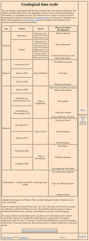
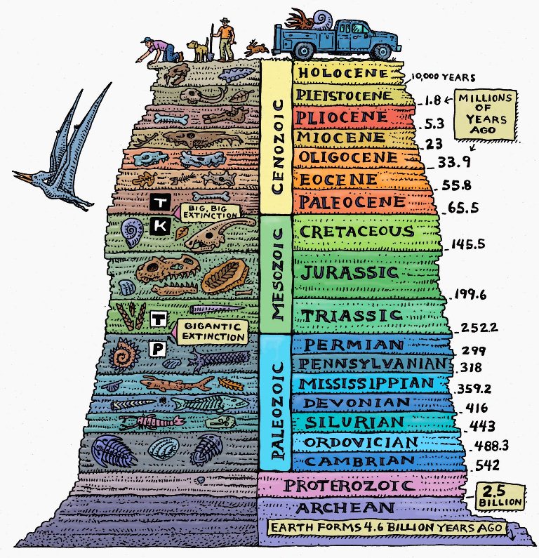
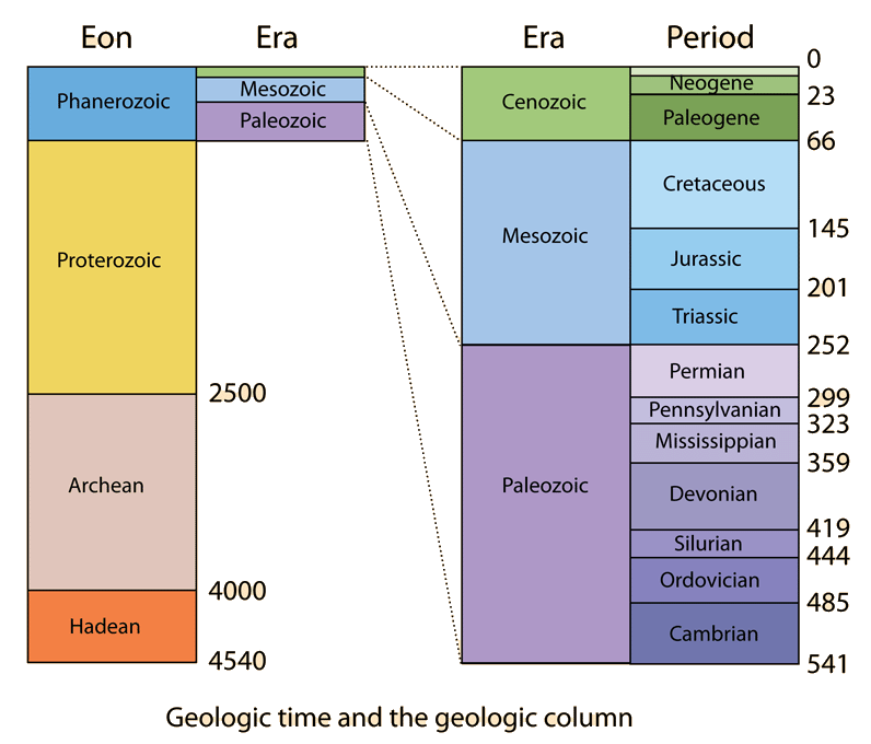
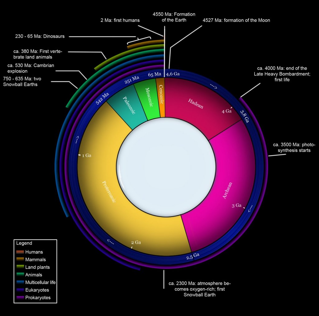
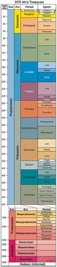
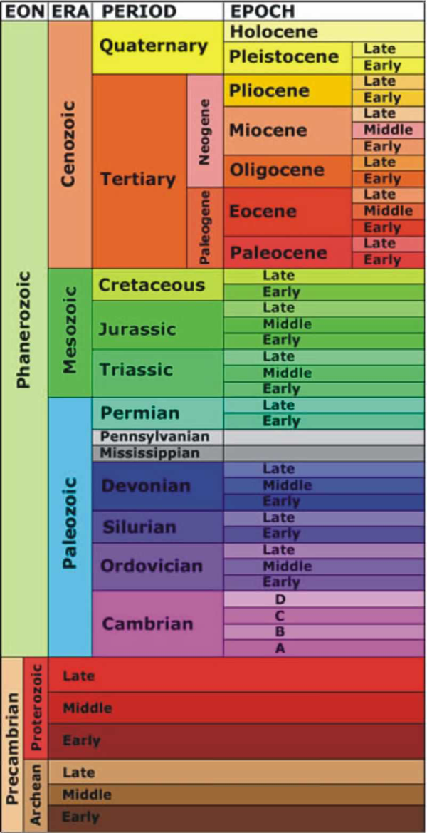
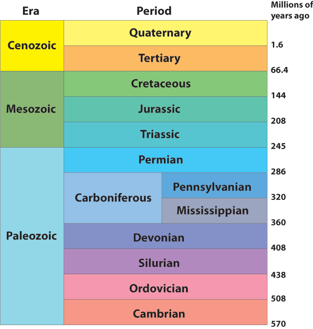
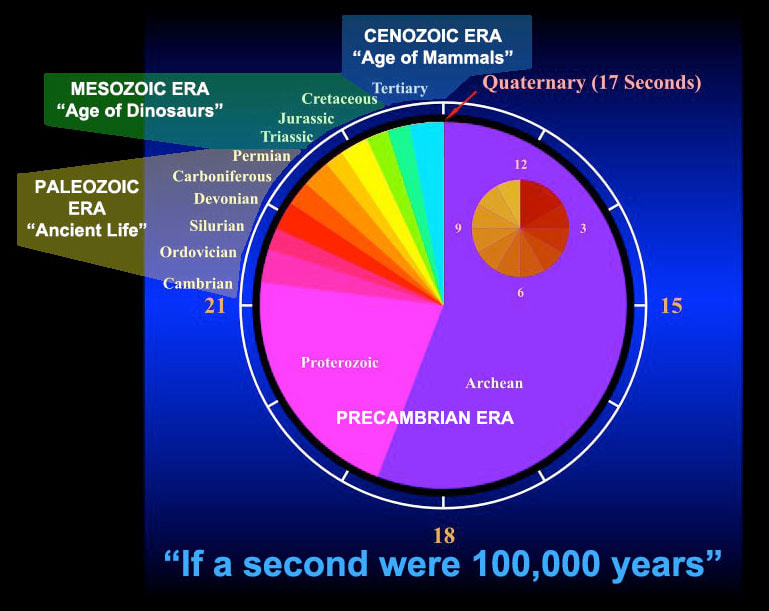
GEOLOGICAL TIME
Eons - Eras - Periods & EpochsThere are four Geologic Eons - the Phanerozoic - Proterozoic - Archean - & Hadean.
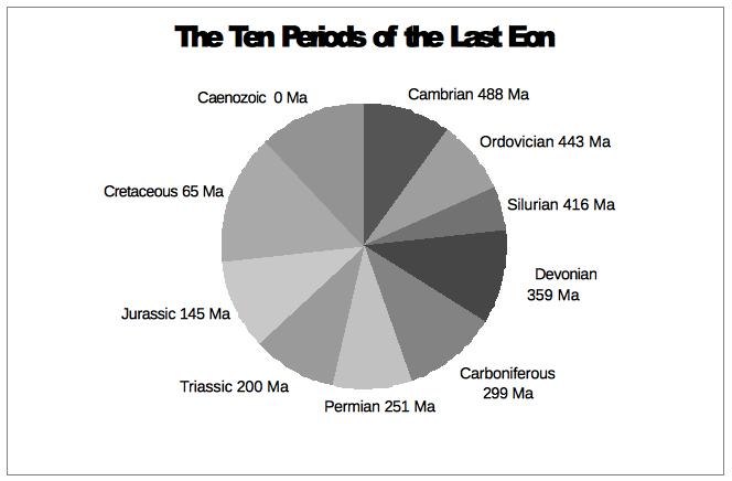
Phanerozoic Eon 540 to 250mya, the earliest & longest - has six Geologic Periods - Cambrian - Ordovician, Silurian, Devonian, Carboniferous & Permian. Proterozoic Eon - Archean Eon - Hadean Eon - Siderian & Rhyacian Periods of the Paleoproterozoic Era - Cryogenian Period 850 to 630mya
The Pleistocene Epoch was the first of two epochs of the Quaternary Period and the sixth of the Cenozoic Era 65mya to present. We are in the Holocene Epoch.
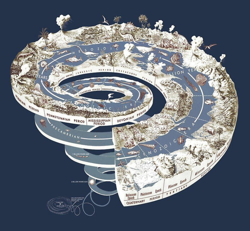
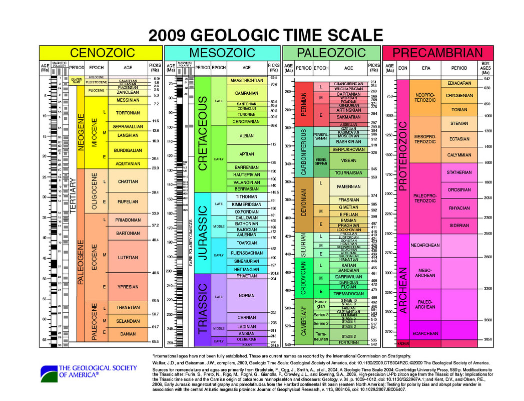
Redbubble GeoTime Poster
|
|
|
|
|
|
|
|
|
|
|
|