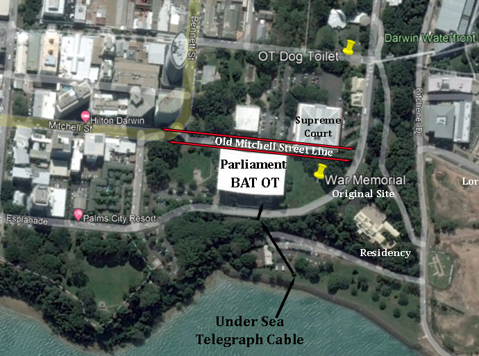
SITING THE FIRST POLE of the OVERLAND TELEGRAPH LINE
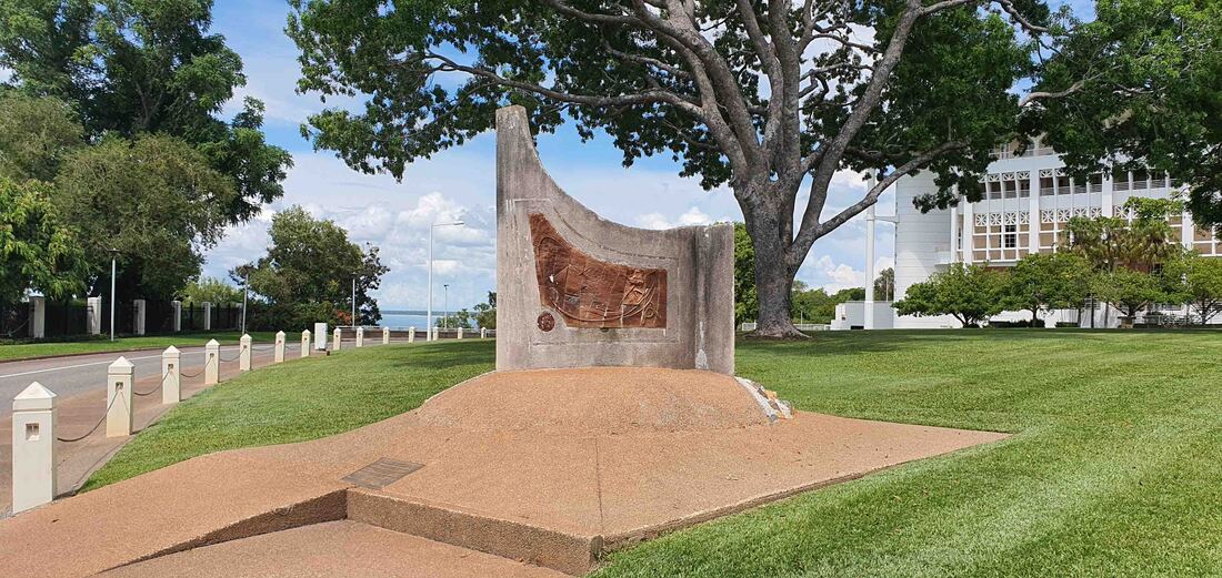
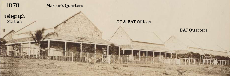
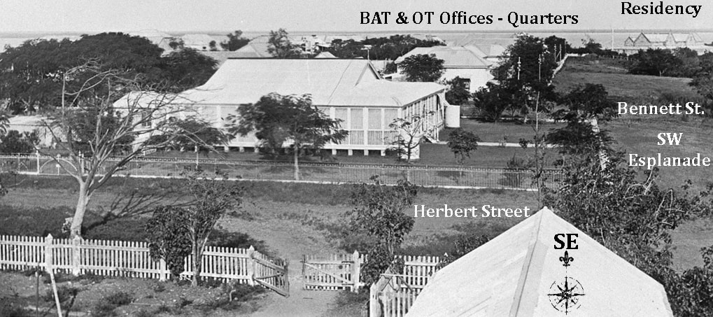
The defunct Overland Telegraph Line Memorial - Liberty Square. Residency at Left - Parliament at right on site of BAT & OT Offices above Cable Beach.
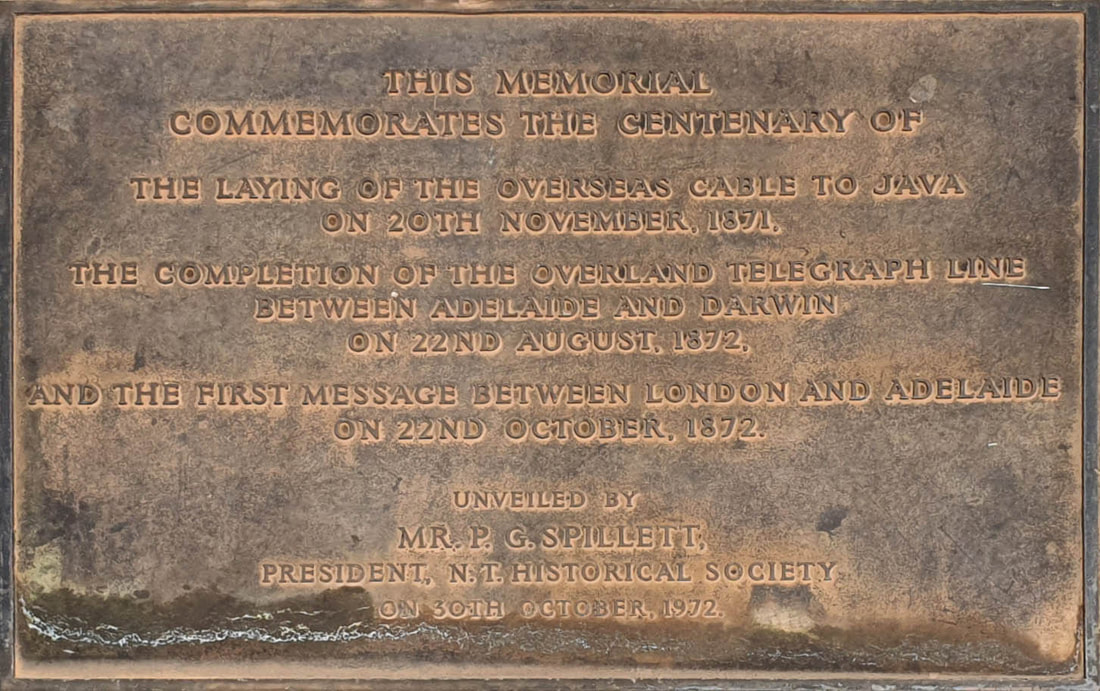
The 22nd of August 2022 was the sesquicentenary (150th) of the joining of the Overland Telegraph Line at Frew's Ironstone Pond - 70kms south of Daly Waters. It is anticipated that the OT Memorial column will be especially shiny that day. In Darwin there is a rarely visited memorial shown above and an even 'curiouser' memorial, a couple of hundred yards away - hiding under a bushel - that purports to be the site of the planting of the First OT Pole in 1870. The erection of a fitting memorial to this momentous event also raises the question of the correct location - which is the objective of this webpage.
It is not entirely clear whether the pole in the Capt. Sweet photograph, staged on the 15th September, was indeed the first OT Pole planted or simply the first for the Northern Section. The Omeo was about to sail and it was a chance to grab the bragging rights for Port Darwin and the northern section. Whatever the case, it predates the Southern Section planting its first pole on Saturday 1st of October 1870 at Stirling - having taken ship from Adelaide aboard the steamer Lubra - "the line has now been fairly commenced at both ends" - according to The Express & Telegraph at Adelaide SA 5th Oct. 1870.
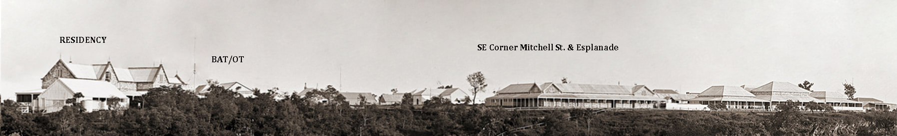
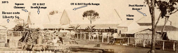
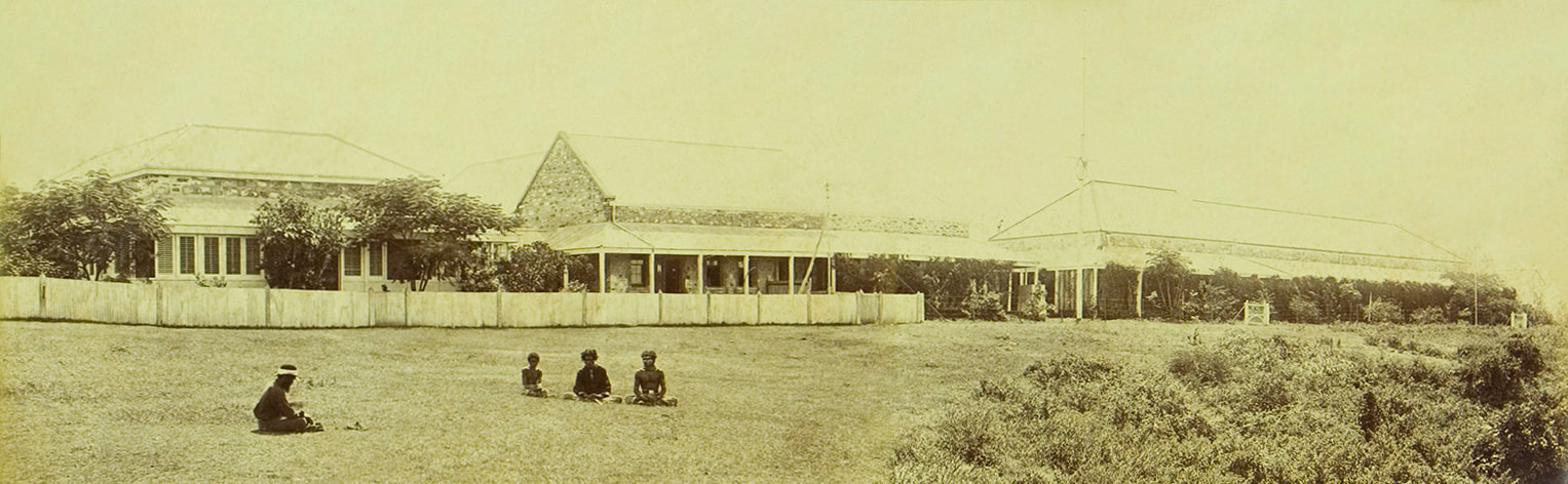
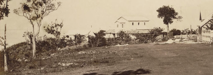
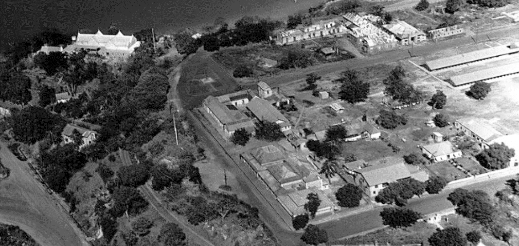
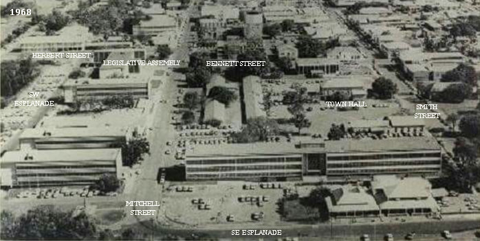
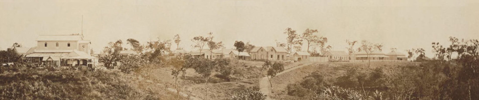
The stitched images below were taken from a 1st floor window of the Residency with the flagpole in its current position at the centre of the carriage loop. The BAT Offices are at left looking across to old Mitchell Street which joined the Esplanade at right of image. At right of centre is the open area once called Liberty Square which today is down to an unregarded quadrant bounded by Government House, Parliament and the Law Courts.

Cnr Herbert St & SW Esplanade to Cnr Smith St & SE Esplanade Oct 1873 - Mike Owen Stitch of NTL PH1060-0034 & NLA.obj-141835455-1 P. Foelsche x Residency Window
Key Dates:-
- 1869 - Contract awarded to British-Australian Telegraph Company - Port Darwin landing site selected - Line Survey Party despatched.
- 5th February 1869 - Goyder's Party arrived Port Darwin to map out the Town of Palmerston - survey completed by end August 1869.
- 15th September 1870 - First OT Pole 'planted' at Port Darwin by Mrs Dominic Daly.
- 7th November 1871 - Telegraph Cable landed at Port Darwin
- 19th November 1871 - 1st international message received
- 300km Pony Express filled the gap in the OT Line to maintain a service until the marine telegraph cable failed in June 1872
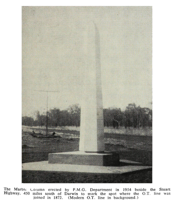
- 22nd August 1872 OT Line connected at Frew Ponds
- 9am Tuesday 22nd October 1872 - marine telegraph cable restored enabling public telegraph traffic between Adelaide & London etc.
n.b. The dates given below are generally estimates except where the author of the image has provided notation on the front in ink. Foelsche took images from fixed points every 5 years. Proposed likely dates are based on the few fixed events and verifiable facts about the people involved.
Memorial to the First OT Pole - Smith St. Darwin
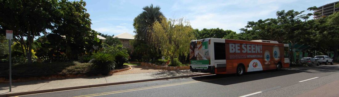
Memorial to the Planting of the First OT Pole - in the flowerbed back left of bus - Smith St. Darwin
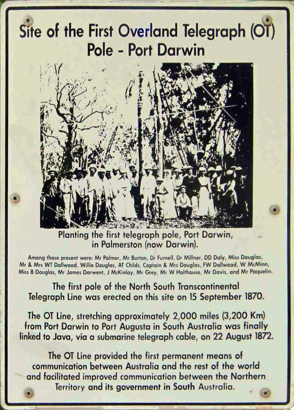
Plaque on 1st Pole Memorial - Smith St.
|
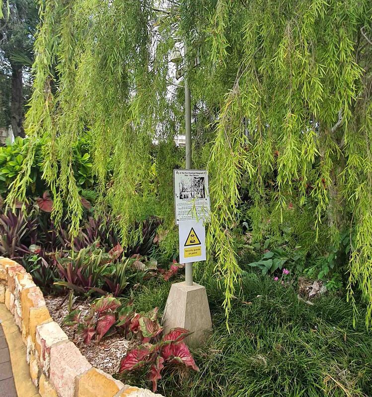
1st Pole Site Memorial - Smith St. - Darwin's only Dog Toilet.
|
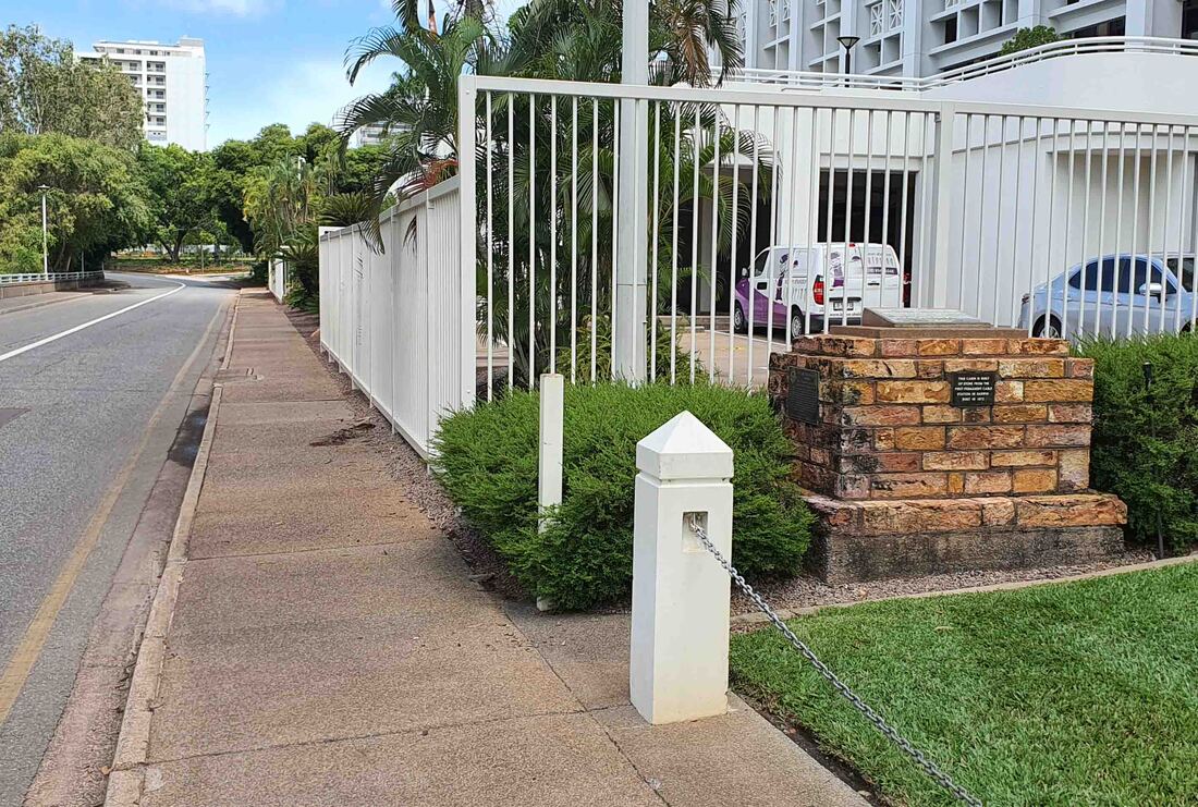
Interestingly the garden wall features ashlar blocks of porcellanite from the demolished BAT & Overland Telegraph buildings which were recovered during the construction of an underground carpark, adjacent to Parliament House, at the location of the old Legislative Assembly building. It is rumoured that the dressed stone from the bombed Town Hall was dumped in the sea to prevent reconstruction and ensure that the proposed NT Museum was a new build.
This lot originally held the Medical Officer's residence and behind it is the Courthouse and cell block - which is the third stone Gaol at Port Darwin - the previous two cell blocks being beside the original Police Station on the SW end of this block - opposite the Residency from where the image below was taken by Inspector Paul Foelsche. The original cells were of timber & seemingly a very crude affair.
This lot originally held the Medical Officer's residence and behind it is the Courthouse and cell block - which is the third stone Gaol at Port Darwin - the previous two cell blocks being beside the original Police Station on the SW end of this block - opposite the Residency from where the image below was taken by Inspector Paul Foelsche. The original cells were of timber & seemingly a very crude affair.
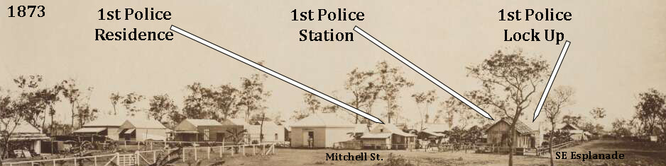
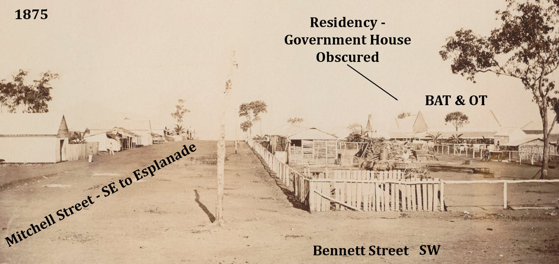
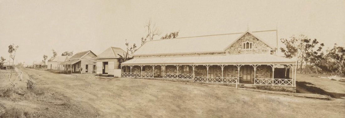
Cnr Mitchell St & SE Esplanade 1873 nla.obj-141835455-1 Foelsche
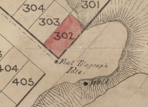
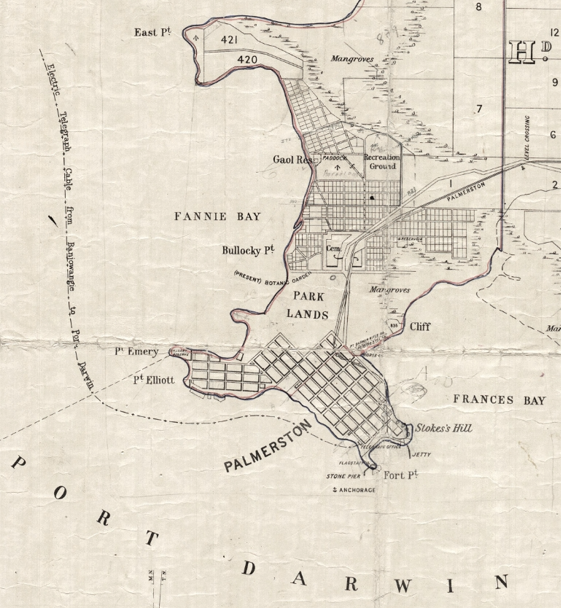
Site Option A - Corner of Smith Street & the Esplanade
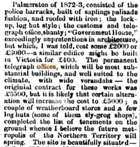
The South Australian Advertiser's own Correspondent's final piece dated June 8, 1873 - "I arrived in Palmerston in July of 1872, at which time — with the exception of Westcott's Gold Prospecting Company — there were only two or three private settlers in the place, and no accommodation-horses {sic}, public-houses, or stores. Now we have six storekeepers, two publicans, two boarding-housekeepers, one saddler, one watch maker, one baker, and one blacksmith....." {Southern Argus 18 July 1873}
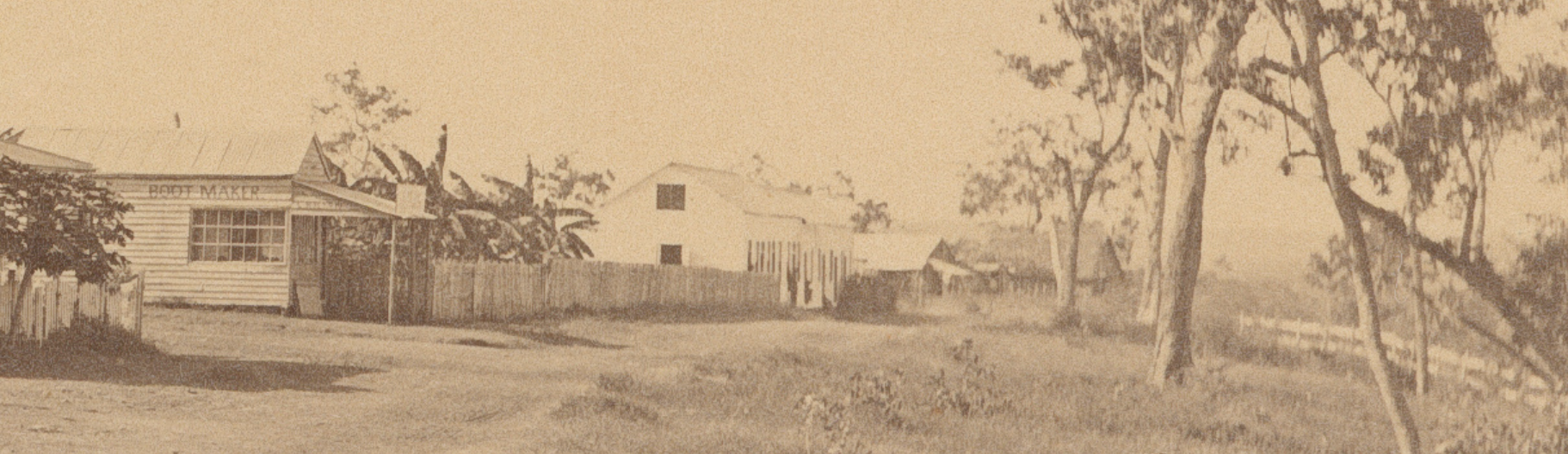
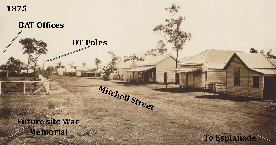
View NE to Boot Maker on Cnr Smith St. & Esplanade. Fence at right is the track down to the Depot. Likely 1879 (Foelsche SLSA B10126 c1870) Zero OT Poles
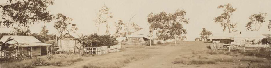
Smith Street looking SE to the Esplanade on 8th June 1875 - (Foelsche nla.obj-141837259-1) Zero OT Poles
Conclusion
Alfred Giles, who wasn't present, wisely quotes a newspaper report siting 'the south-east end of Kavanagh Street{sic}' & Mrs Dominic Daly is silent on the matter. The Correspondent of the South Australian Advertiser also plumped for Cavanagh Street & the Esplanade though he doesn't appear to have been invited to the event. No reference to this location for the 1st OT Pole has been found. Given the distance from the OT/BAT block & the identified landing site of the cable, as well as the paucity of anything much at all on the Palmerston Plateau in 1870 it seems an unlikely choice.
Site Option B - Corner Cavanagh Street & Esplanade
nla 146757666 - 'General' Giles, Brocks Ck JP Campbell 1912
|
In 1870 Alfred Giles had joined John Ross’ party to plot a course for the Overland Telegraph Line through the MacDonnell Ranges, so was not present at the event.
In Chapter XXIV (p.106) of his 'Exploring in the Seventies and the Construction of the Overland Telegraph Line' quotes from a newspaper clipping which he presumes to be from the SA Register as it pre-dates any NT publication. "The first telegraph-pole was erected to-day, close to the south-east end of Kavanagh Street, Palmerston, in the presence of the Government Resident and family, Mr. and Mrs. Dalwood, the officers of the expedition and many local residents. A photograph of the interesting scene, taken by Captain Sweet, is here reproduced through the kindness of Mr. E. J. Moody. Mrs. Dalwood broke a bottle of wine over the pole and drove in the first insulator-pin. The pole was then raised in an upright position in the hole, and Miss Douglas had the honour to ram the earth around the base with a rammer (made for the occasion) of hard, polished wood." {See image at bottom of page} Giles is of the opinion that the bottle contained tea - he being unable to countenance any such profligacy. There is no photographic or other documentary evidence to support this location. |
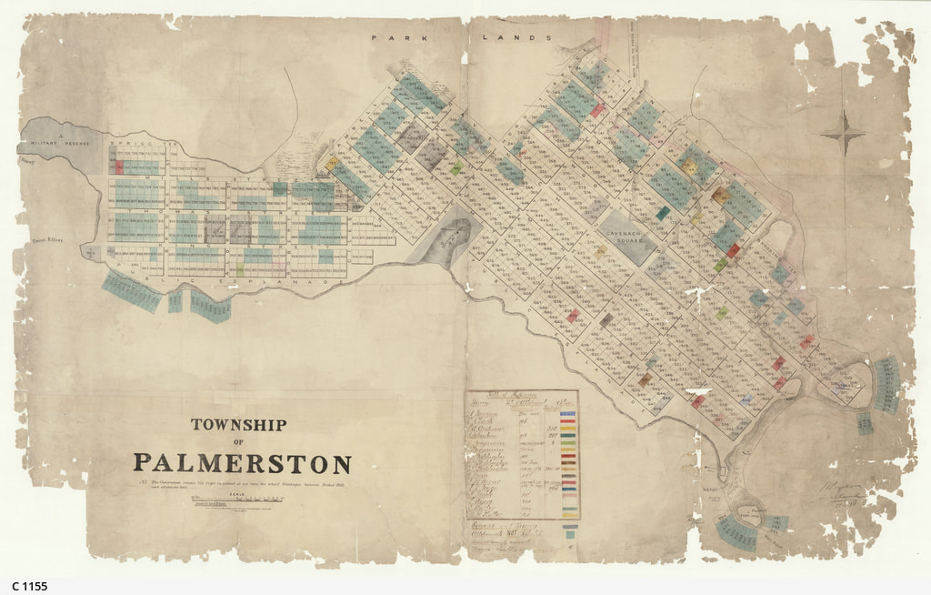
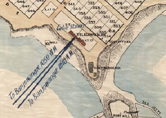
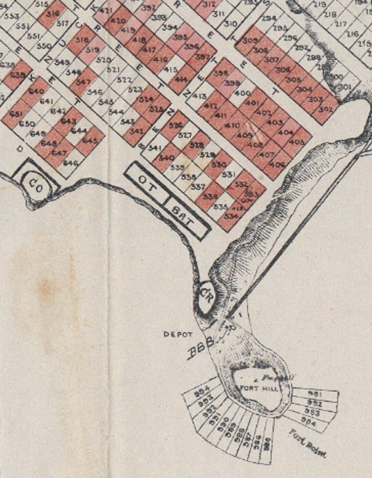
Map of Palmerston (SLSA C-1155 seen below right) - clearly marks the location of the 1st OT Pole at the SE junction of Cavanagh St & the Esplanade. Below left is a detail of the location of the pole and below that is the Morse Code 'Dots & Dashes' representing Pole Line Pole trajectory of the Telegraph Line - up Cavanagh Street, past Cavanagh Square, to a right turn onto Daly Street which it follows out of town - on the 'main road to Fred's Pass'.
Detail of above - SLSA C-1155 ES Berry June 1880
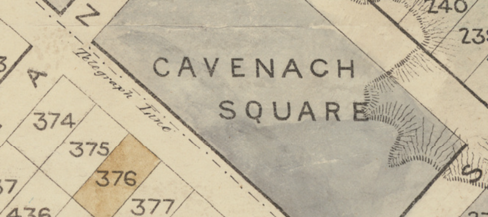
Detail of above SLSA C-1155 ES Berry June 1880
|
SLSA C-1155 (1) June 1870 showing site of 1st OT Pole & Telegraph Line up Cavanagh St to Daly St.
|
Conclusion
ES Berry's map of the Township of Palmerston was published by the SA Surveyor General's Office in June 1870 - 3 months before the planting of the first pole on 15th September. The political pressure to present a substantial township to investors is understandable, given the reality of the situation just 6 months after the Goyder's Party stopped bashing pegs into the ground although the OT & BAT 4 acres must have been surveyed and pegged during this time. It is curious that the OT & BAT Offices do not appear on the maps until 1887, by which time neither the Telegraph Line nor the 1st Pole are shown. No other supporting photographic or documentary evidence for this location has been encountered. The Omeo brought the Telegraph Party but also a party of Land Selectors who had purchased blocks {some during the Escape Cliffs escapade} which they now selected in the festive mood of the day.
Official Planting the First OT Pole 1870
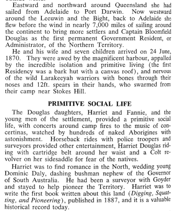
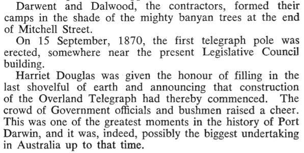
Mrs Dominic D. Daly (Harriet) recalled the arrival of the Overland Telegraph Line Contractors aboard the Omeo - early in September 1870. "The horses were landed first - hoisted in slings and lowered into the water they were released, and swam to land. Drays were floated ashore, their wheels following them in a boat, and a large telegraph camp was formed on the tableland overhead. " (p83 Mrs DD Daly Digging, Squatting etc).
Turn around time for the Omeo was a little over a week - pricking the professional photographer instincts of Captain Samuel Sweet to stage a 'photo-opportunity' - Planting the 1st OT Pole - & get the images south with the Omeo. Good PR for the SA Government, Line Contractors & a Sweet commission.
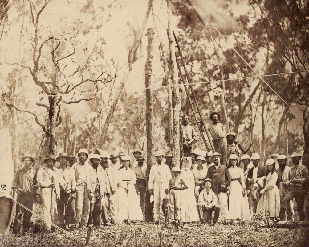
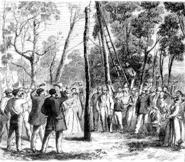
Planting of the first Overland Telegraph Pole - 15th September 1870 Capt. Sweet SLV
|
Illustrated Australian News for Home Readers 5 Dec. 1870 - P. 208
|
Image Comparison
Above left is the formal group before the planting reproduced as Albumen Silver print from a glass plate - State Library of Victoria. This is a carefully staged photograph choreographed by Samuel Sweet who was a trained professional photographer, as well as deep sea mariner.
At right, the cheers that followed the actual planting of the pole. This NLA image 'Planting the First Post' - 'amid great rejoicing' on "the corner of Cavanagh-street and the Esplanade." It was printed in a periodical - probably from a plate inscribed from a sketch or a staged Sweet 'action' exposure that is not discoverable. It fits the described event and the characters from the original photograph are carefully rearranged with the sun setting in the East like the Fighting Temeraire.
The tent at left, bearing Sweet's anchor logo, has retreated to the background in the righthand image and there is now considerable space between the planted pole and the tree with the ladder - preparatory to receiving its own insulator. By this time the shadows were lengthening as, according to the slightly peeved local correspondent of the South Australian Advertiser, "The ceremony took place at half-past five o'clock. Nearly all were present, although no invitations were issued except to a few - the Government Resident's family, &c. None of the officers of the settlement were asked, and, in fact, the invitations were 'invitations to stop away'-".
Conclusion
The Illustrated Australian News of December 1870 reported the planting at the corner of Smith Street and the Esplanade. The planting was just over a year after Goyder's Party completed their survey - so whilst the Town of Palmerston looked good on paper - in reality the scant populous lived down at the Depot whilst, up on the Palmerston Plateau, there was little more than the new OT camp as described by Harriett Daly and lines of survey pegs in virgin scrub - also perhaps a slightly miffed correspondent who was seemingly amongst those officers not invited to the event & so relied upon second-hand information amid his haste to despatch some copy with the Omeo. Mrs Daly's recollection of performing her first public ceremony of fixing the pole "Amidst a gathering of the whole community" may be hyperbole as it seems likely that the real reason for not inviting 'the officers of the settlement' et al was that it was simply a publicity stunt - akin to launching the first Collins Class Submarine with a painted ply board conning tower.
Image Analysis
|
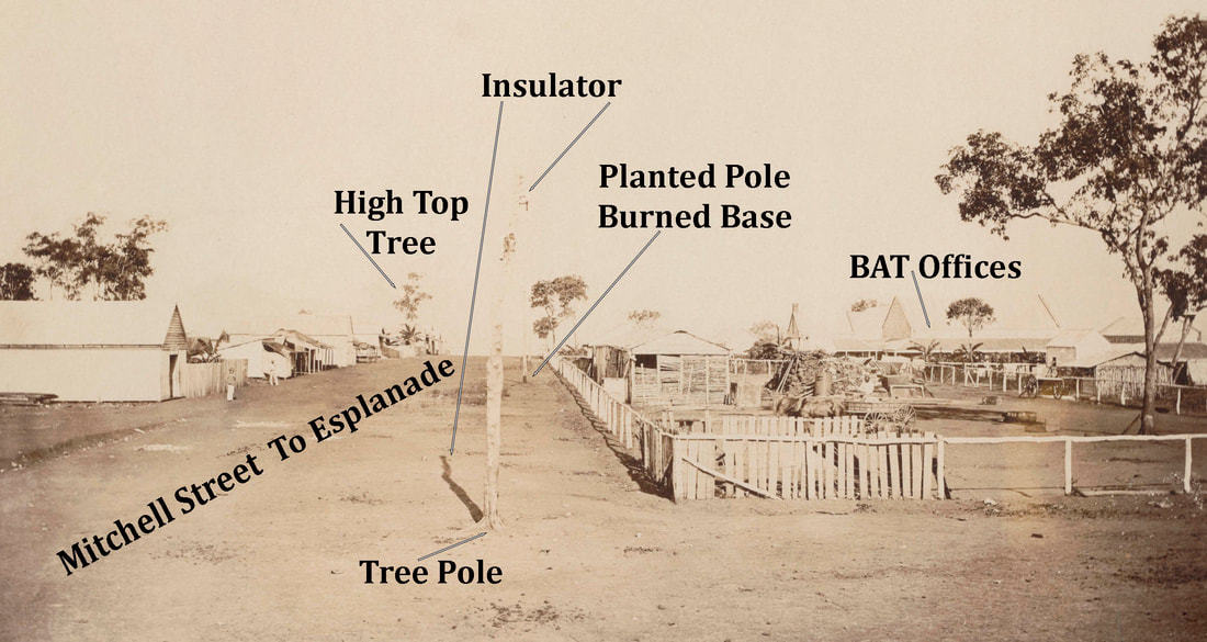
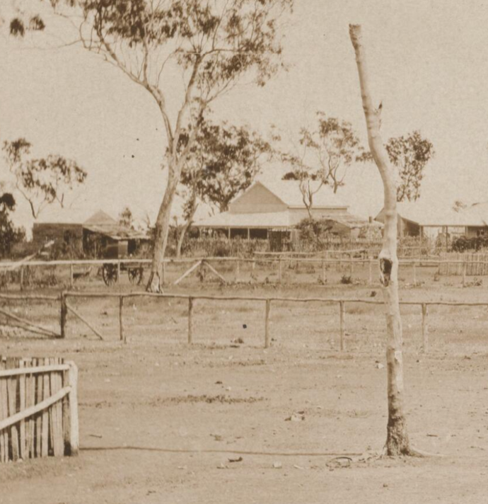
1. The Tree Pole The ladder is against a tree that has an unusual flare in the trunk below a kink which takes the trunk out of focus away from the viewer. It appears that this tree is subsequently repurposed as an OT Pole - in keeping with the directions to contractors provided by Charles Todd.
2. The Second Pole in the Picture The Pole in the formal image above has the bottom 3ft burned as per contractors directions - the burned section is above ground. The pole does not appear to be fitted with a standard single insulator spike and nobody would dig a hole so close to a living tree. In the image at right -the second pole in the line of three, beginning with the tree pole, is a cut pole with the collar of the singed bottom clearly visible. 3. The Third Pole This pole is straight and adjacent to the gate entrance to the OT & BAT Offices from where it is the first pole in the OT line to Adelaide. In the 1879 image, it appears to be immediately behind the open sided stables/shed in front of which is a straight tree with a branch at the top. In front of which is another tree with a signature 'platform' or fixed cross member - opposite which is VL Solomon & Co. in images below. 4. Location The presence of the tent & numerous guy ropes suggest the site is at the aforementioned 'Telegraph camp' on the cliff-top block assigned for the Overland Telegraph & British Australian Telegraph Company offices which were completed in 1872. Both images show insulators on either side of the pole when a single wire requires only an insulator on one side or at the top except at a junction.
|
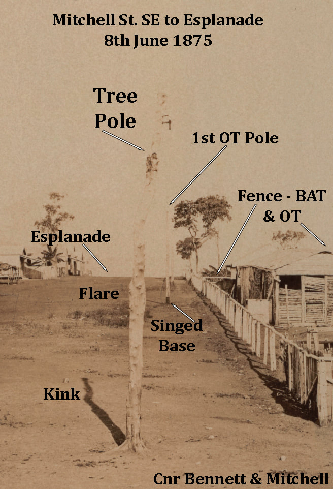
Detail NLA PIC P827/21 Mitchell St. SE below
|
nla.obj-141836855-1 Mitchell Street looking NW, 8th June, 1875' - P. Foelsche
|
NLA PIC P827/21 'Mitchell Street looking SE, 8th June, 1875' - P. Foelsche
|
|
Glenville Pike in his 1971 paper 'The Northern Territory Overland Telegraph' gets close when he records that the pole was planted in Mitchell Street in the vicinity of the Legislative Council building which was to the immediate NW of the current Parliament House. He also correctly places the OT Line camp amid the trees on Mitchell Street.
{Pike, Glenville (1971). The Northern Territory Overland Telegraph : an epic of courage - just 100 years ago. Journal of the Royal Historical Society of Queensland 9 (2) 95-133.} |
G. Pike TNTOT p132
|
"Behind the First Pole the stone walls of a post-office emerged like a giant ant-hill from the hore-hound scrub, with a galvanised-iron roof so new and dazzling that birds of the air alighted there, believing it to be a lake. The post-office was the beginning and its fall the tragic end of Darwin's civil history." The Territory - Ernestine Hill 1951 p100.
Conclusion
The landing site of the cable was selected and the location of the OT/BAT buildings determined, long before the planting of the 1st OT Pole.
The OT Party made camp on their surveyed 4 acre OT/BAT block. The tents & guy ropes are visible in Sweet's image(s) & described by Mrs D. Daly.
The opportunity arose to stage a Publicity Stunt 'Planting of the 1st Pole' to steal a march on the other sections of the line - Sweet was a professional.
The obvious site was in the middle of the OT/BAT block - where the OT Party was camped - where the cable terminated & where the Post-Office would be.
The first image is a group shot of VIPs - no 'officers' or settlers etc & no cannon fire. The Pole is singed but unplanted & supported by a distinctive tree.
The second image - an engraving - shows the Pole planted some distance in front of the distinctive tree - which is itself to be recruited as a pole.
The characters of the 1st image are rearranged, some of the contractors etc are missing - the tent bearing Sweet's mark has retreated to the background. It is improbable that such meticulous attention to detail or rigid composition of the '3 cheers' moment is cut from anything but a 2nd photograph.
The prominence and preservation of these poles, in the tumultuous growth of early Darwin, is exceptional.
Their forensic photographic documentation from every angle by Inspector Paul Foelsche is significant.
That Foelsche should diligently & systematically record the development of Darwin and not photograph the First Pole is unreasonably - not least because he actually attended the event and is seen, at extreme right, in his favourite shirt.
Ockham's Razor supports no other location than the easiest, most obvious & only documented site being in Mitchell Street - in line with the post-office wall.
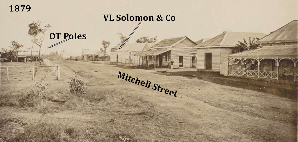
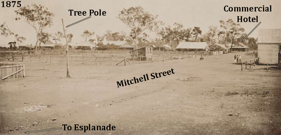
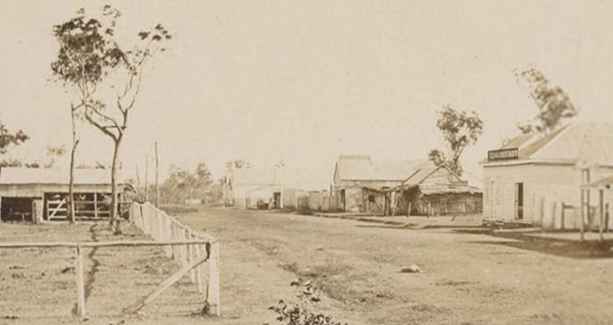
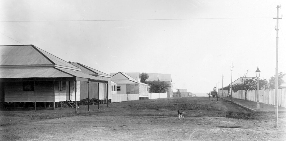
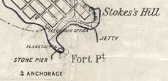
Site Option C - Mitchell Street 1875
SLSA B5060 Corner of Mitchell St & SE Esplanade
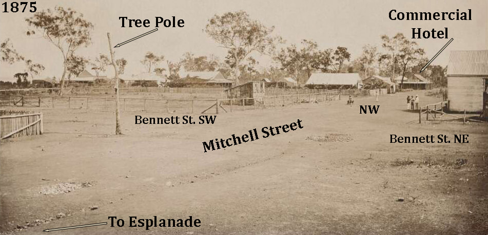
Mitchell St. looking NW June 1875
|
Mitchell Street, Port Darwin, looking NW June 1879 - OT poles at left - Esplanade at right
|
1879 nb tree at centre left
|
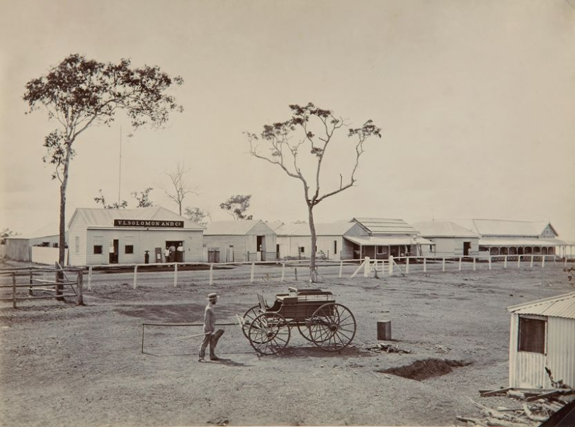
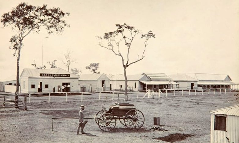
VL Solomon Mitchell St. 1879 - nb tree at centre
|
Vaiben Louis Solomon (1853-1908) - who became Premier of South Australia for a week - opened these premises in 1877 & entered into partnership with F. P. Stevens and H. H. Adcock in 1878 as VL Solomon & Co. In 1885 they built a stone warehouse 'Solomon's Mart' on Smith Street which is no Brown's Mart. That the OT Poles are opposite original Solomon's Store may have inspired confusion as to their location.
PIC P827-21 LOC Album 914-1&2-nla.obj-141837352 - Foelsche 'Mitchell Street looking SE, 8th June, 1875'
Detail - OT & BAT on Cnr Bennett & Mitchell Sts
|
nla.obj-141836855-1 June 1875 - incorrectly labelled The Esplanade (Kelsey)
|
The image above shows the intersection of Michell and Bennett Streets. The Tree Pole is on the corner of the OT section of the OT & BAT compound shown on the map above. It is noted that there is no telegraph wire nor further telegraph poles in view. The second exit on the left where the man in white is standing alone is Herbert Street.
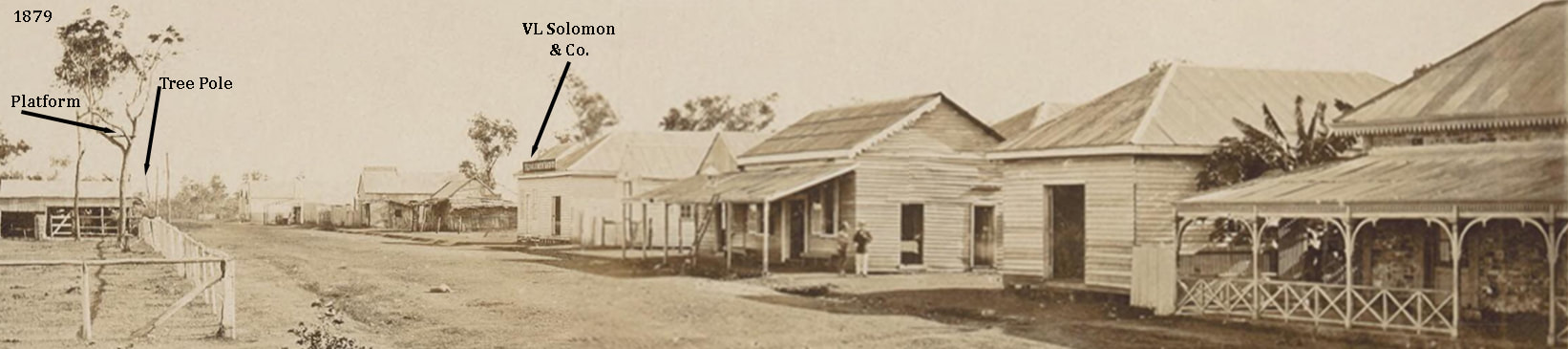
The two gum trees in front of the stables/shed appear to be just a few feet apart in the image below left but the image on right - taken from within the OT & BAT compound - are perhaps 50ft apart - if the fencepost are 4ft proud & 8ft apart.
NLA 1879
|
AGSA 1879
|
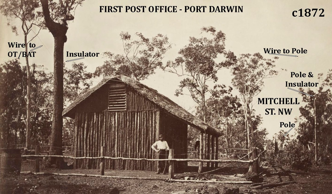
FL15842941 Sweet 1st Telegraph Office 1869-70
|
There is neither location nor date given for the Sweet (5) image of the First Post Office - which may include the first Post Master JAG Little - it is here suggested that it was located on the OT/BAT block on Mitchell Street. This was land selected by Todd for this purpose - it was 'off survey' so not available to anyone else to select & was 'owned' by the SA Government which owned the OT Line and all that went therewith.
If it is Mitchell Street - the building is on the correct side of the line of poles. A pole at right carries the line across to an insulator on the tree. From there it runs into the vent & another line comes to left of image - presumably towards the shared OT/BAT Cable Terminal Building. Little was photographed by Sweet with Todd and party at the Roper in early 1872. The tree beside the building's left corner is itself unusual and closely resembles the one shown above which was seemingly fitted with a platform - perhaps for a lookout before the steamer tower was built or a bell arm like the church. |

NTLIS 1887 - Abandoned BAT 'Cable Office' location Cullen Bay
|
Telegraph Line Trajectory
The scarcity of original timber Telegraph Poles in the digitised image record - combines with the dearth and inaccuracy of documentary sources - to make the trajectory of the line problematic and it probably changed over time. The SE Esplanade would perhaps be favourite but there is no evidence of it - ditto the SW Esplanade though the former may have been utilised when Oppenheimer Poles arrived from 1874 onwards. The images show poles in Mitchell Street but only as far as the Bennett Street corner & they do not appear to carry wire though they are faint & perhaps feint. The wire does not appear to pass the Commercial Hotel but turns down Bennett Street.
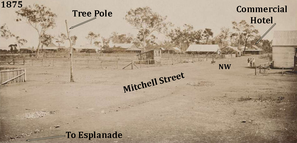
Mitchell Street looking NW
|
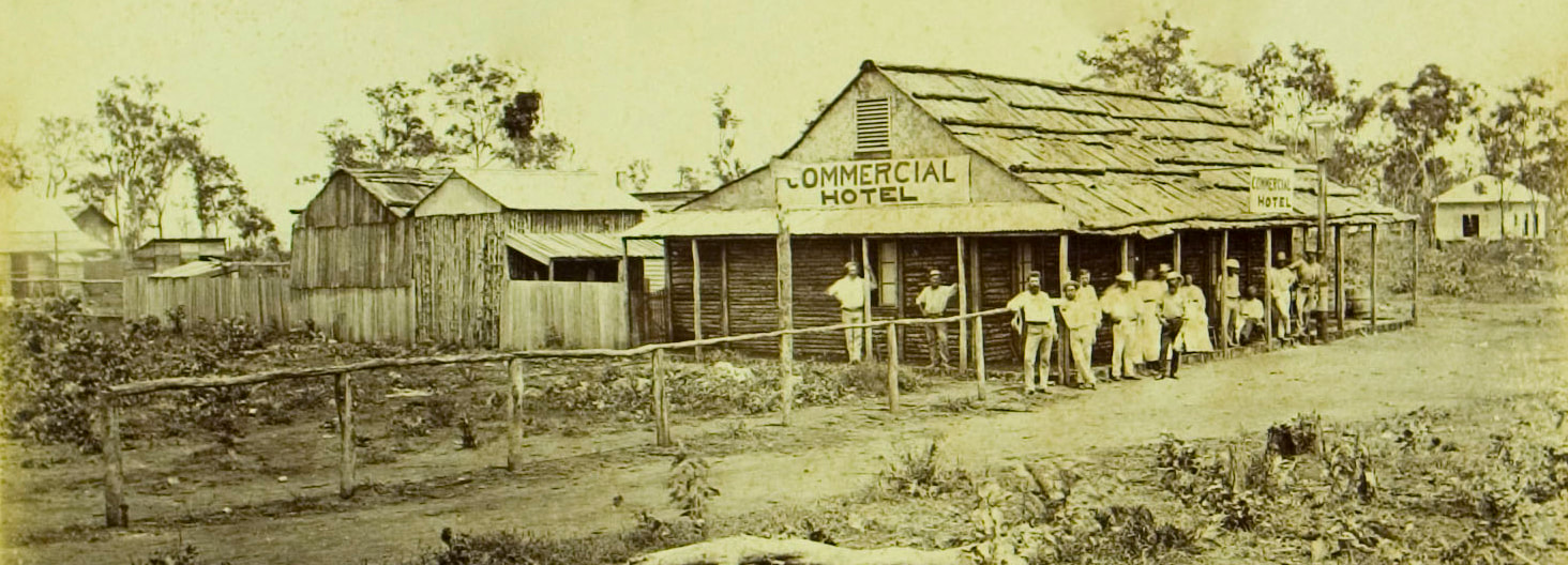
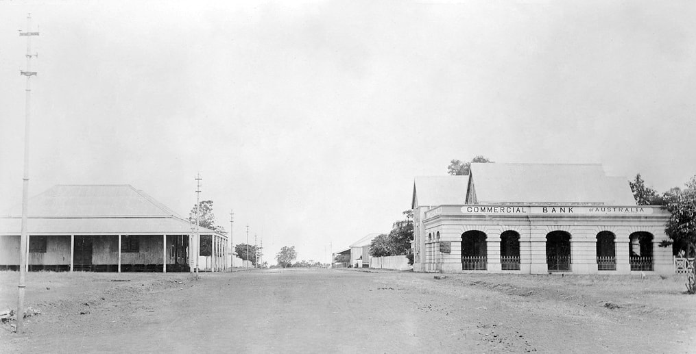
Commercial Hotel - Mitchell Street February 1874 Foelsche
|
Bennett Street
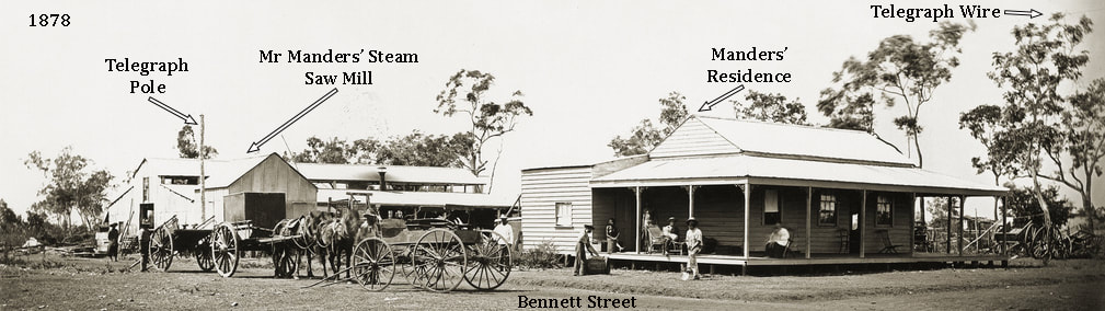
SLSA B-5038 Mr. Manders' residence and steam saw mill, 1878 - Cnr Smith & Bennett Streets
Detail of OT Pole above B-5038
|
Detail of OT Pole above B-5038
|
The Foelsche image above shows an original pole with insulator atop and the single wire running in front of the trees at right. Thus the telegraph line ran up Mitchell Street & down Bennett Street and did not run down Smith Street which leaves Cavanagh, Woods & McMinns Streets.
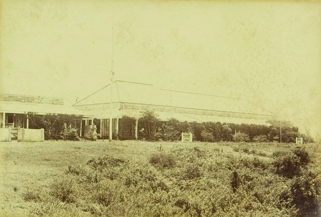
SW Esplanade - OT & BAT Buildings
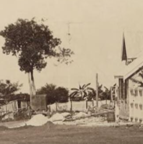
Detail of images above - BAT Offices - rear view of stitch image above. 1875
B-8752 1872c 30.2x25.1 - NLA obj-141838308 May 1878 - Moire Album PH1060 p23 Foelsche notation 'Telegraph Buildings 1873'
|
The 1875 image below clearly shows the 'C' shaped buildings as described by Charles Todd - 'a very large building, consisting of a central building and two wings.......The central building comprises three offices, one of which is used by the British Australian Company. The other two are used by the Department, one for an operating-room, the other for the public on the business of the Telegraph, Post-Office and Customs.'
The public entrance was from Mitchell Street as there was no road on the Esplanade at this time. Travellers complained of having to navigate past pig pens & middens to get to the Telegraph Office. The buildings change greatly over time but it is a challenge to reconcile the view from Mitchell Street with the view from the Esplanade above. |

SLSA CDC-10783837 Full image - detail below
|
View from Cnr Bennett & Mitchell Sts looking South to OT & BAT Bldgs 1875
nla.obj-141838403-1 O.T. Telegraph Station, Masters Quarters and Office, May, 1878 Foelsche
SLSA B 10840 c1870 'The Telegraph Offices' - much later
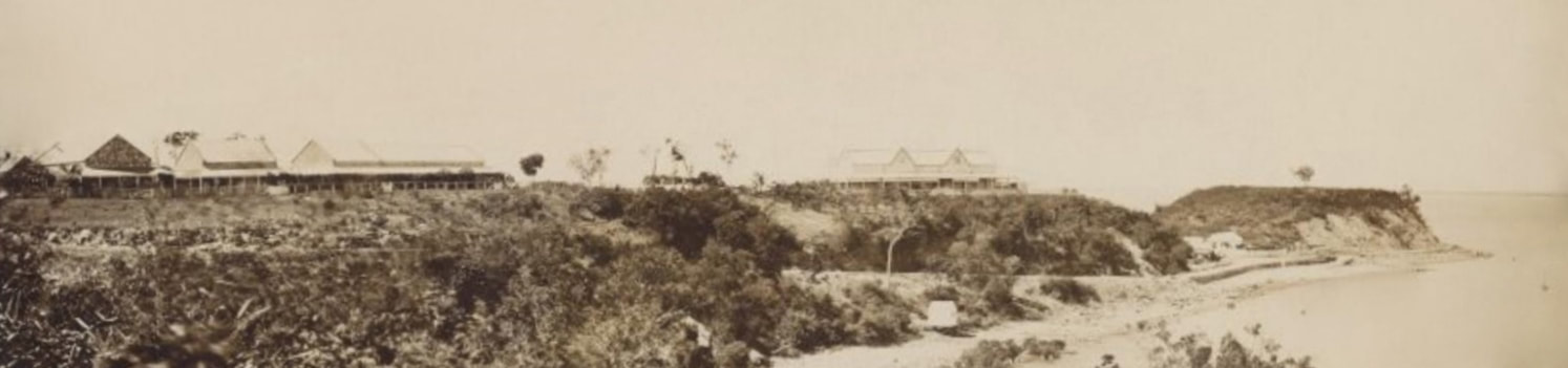
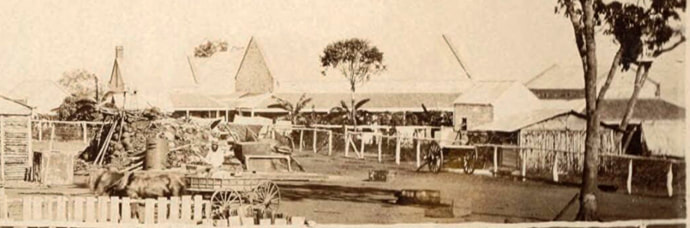
Mike Owen stitch BAT & Residency completed in 1879 - white metal shed on beach receives the undersea cable
This is the back of the OT & BAT buildings - it is open land above Cable Beach - to the right is Liberty Square
nla.obj-141838403-1 O.T. Telegraph Station, Masters Quarters and Office, May, 1878 - if this is correct what is the house at left out of frame
Adelaide Observer 11 January 1873, p. 11.
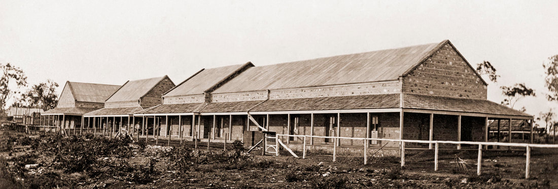
Mr Todd noted: "At Port Darwin it was necessary to provide offices and quarters for the staff of the British Australian Telegraph Company, in addition to the offices and quarters for our own staff. We had, therefore, to erect a very large building, consisting of a central building and two wings. The site chosen was the one originally recommended by Todd on the esplanade near the Government residence facing the harbour, of which a fine view is obtained.
The buildings were of stone, roofed with iron and were surrounded by a broad verandah; the floors were concrete to prevent the woodwork being destroyed by white ants. There were also outbuildings for stables, stores, workshops, &c., and two large underground tanks, each capable of holding 12,000 gallons of water. The buildings stood on four acres of ground, fenced in and half of which were conveyed to the Company, who of course paid for the cost of their portion of the building.
The central building comprises three offices, one of which is used by the British Australian Company. The other two are used by the Department, one for an operating-room, the other for the public on the business of the Telegraph, Post-Office and Customs.
The South Australian quarters comprise a house of five large rooms, a detached kitchen, and bath room for the Stationmaster, and two detached rooms for one assistant operator, the men being accommodated in adjoining huts of wattle and daub.
The British-Australian quarters consisted of a long range of buildings, containing 10 rooms in all, being quarters for the Resident Superintendent and five (5) assistants. The rooms were large, one being a billiard-room and library, a handsome billiard-table and a good collection of books being provided by the Company, who also gave their officers a light rowing gig."
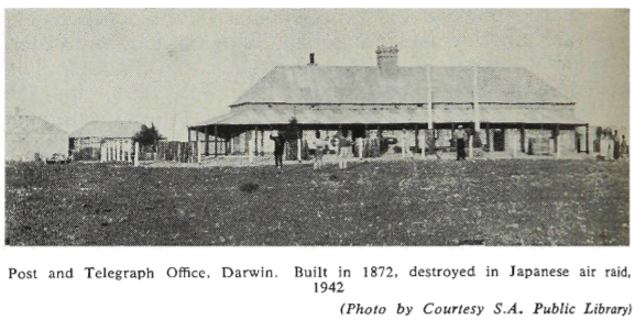
The Overland Telegraph Building and the British Australian Telegraph Company buildings were destroyed by bombing on 19 February 1942.
(TelegramsAustralia)
Mr Todd noted: "At Port Darwin it was necessary to provide offices and quarters for the staff of the British Australian Telegraph Company, in addition to the offices and quarters for our own staff. We had, therefore, to erect a very large building, consisting of a central building and two wings. The site chosen was the one originally recommended by Todd on the esplanade near the Government residence facing the harbour, of which a fine view is obtained.
The buildings were of stone, roofed with iron and were surrounded by a broad verandah; the floors were concrete to prevent the woodwork being destroyed by white ants. There were also outbuildings for stables, stores, workshops, &c., and two large underground tanks, each capable of holding 12,000 gallons of water. The buildings stood on four acres of ground, fenced in and half of which were conveyed to the Company, who of course paid for the cost of their portion of the building.
The central building comprises three offices, one of which is used by the British Australian Company. The other two are used by the Department, one for an operating-room, the other for the public on the business of the Telegraph, Post-Office and Customs.
The South Australian quarters comprise a house of five large rooms, a detached kitchen, and bath room for the Stationmaster, and two detached rooms for one assistant operator, the men being accommodated in adjoining huts of wattle and daub.
The British-Australian quarters consisted of a long range of buildings, containing 10 rooms in all, being quarters for the Resident Superintendent and five (5) assistants. The rooms were large, one being a billiard-room and library, a handsome billiard-table and a good collection of books being provided by the Company, who also gave their officers a light rowing gig."
The Overland Telegraph Building and the British Australian Telegraph Company buildings were destroyed by bombing on 19 February 1942.
(TelegramsAustralia)
NTRS 3420_P1_photo 19 - Item 19 D2: OT [Overland Telegraph] Officers quarters 1887 - 1887
|
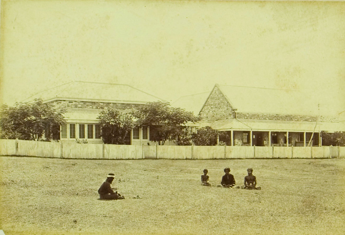
NTRS 3420_P1_photo 18 - quarters [on the left]; [four Aboriginal people sitting on the grass in the foreground]
Item D2: 1887 - 1887
|
NTRS 3420_P1_photo 15 - On the left is the Overland Telegraph Terminal and building on the right is the Cable Station] Item D2: 1887 - 1887
|
The photographer has shifted position elongating the central Terminal Building
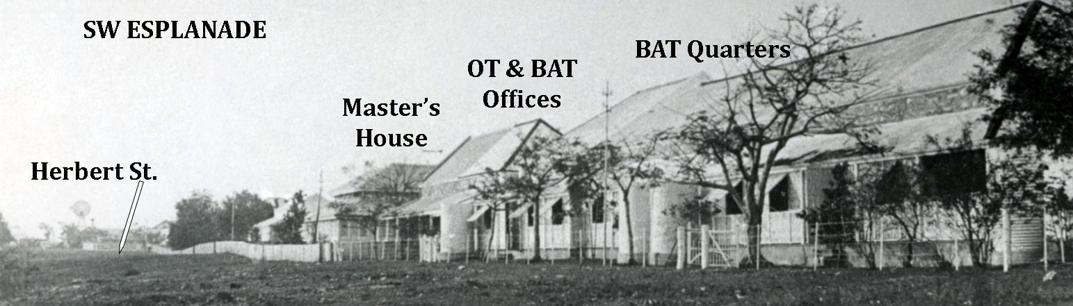
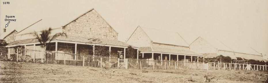
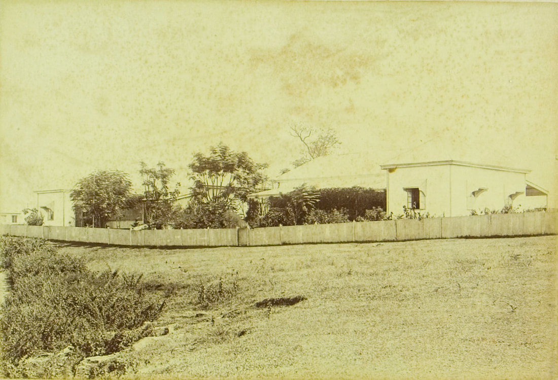
Image on left above is the BAT Offices from the SW Esplanade showing the square chimney that features in the image below. The Residency is behind the BAT/OT Offices and obscured. The Residency does not have chimneys on the gable end.
NTL PH1060-0034 c1873 view from the Residency buildings completed 1873
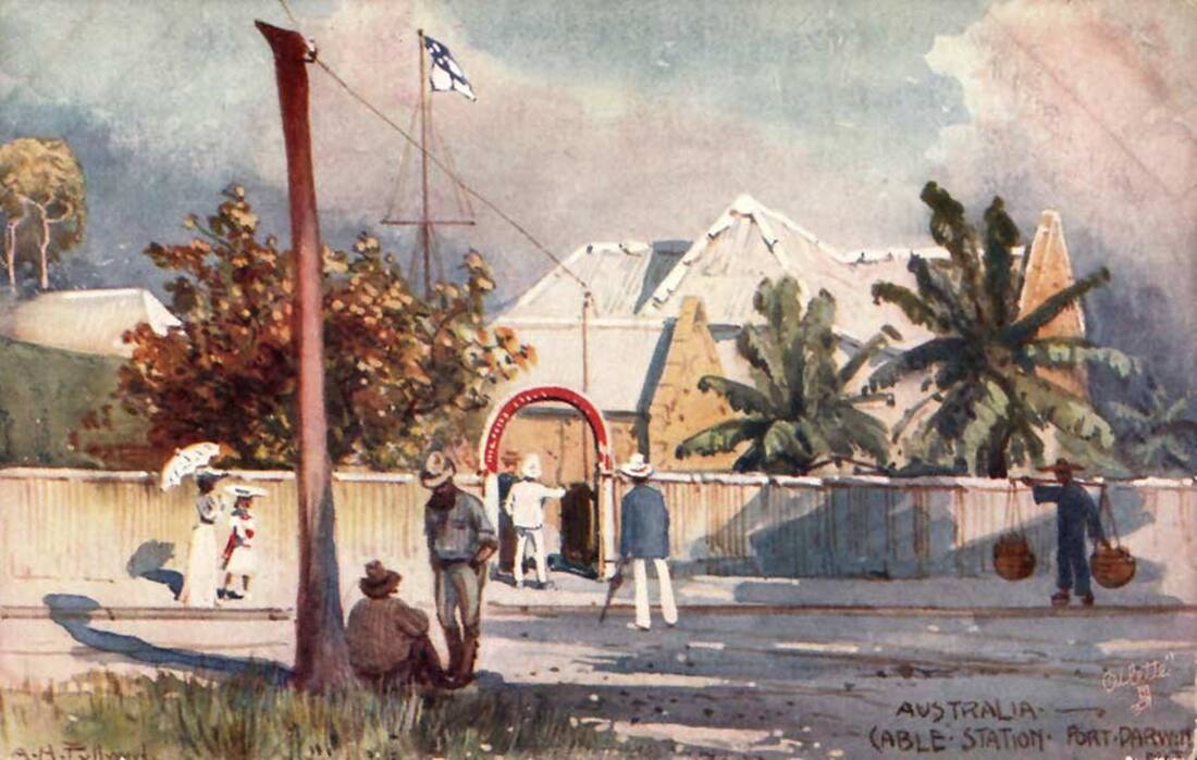
Tuck's Post Card Cable Station Port Darwin c1900
|
Original by Albert Henry Fullwood 1896
|
The Post Card of Port Darwin was painted by AH Fullwood - perhaps from a sketch - he travelled widely. The stepped roof at top left resembles the long BAT quarters building. The postcard was printed in England, as part of a set of 6 on the Australian Post and Telegraph System, first appearing on 27/3/1906 and went on sale in Australia, Great Britain & the United States of America. The Residency appears to be flying the Stars & Strips & perhaps a SA flag - Federation flag - courtesy to a visitor in residence or it's South Africa. The flagstaff could not be that high as the ground dips away sharply to the Residency and it would out of view to the far left as the access to the buildings was from Mitchell Street which also puts the telegraph line in the wrong place. No other images of such an entrance arch to the Post Office & Telegraph Office at Port Darwin are known - perhaps it's elsewhere or just a printers fancy.
SLSA B-53778 view SE c1890 - Superintendent's Residence at centre
This view appears to show the poles carrying multiple lines processing from the SW Esplanade side of the BAT & OT buildings along their fence line to the SW and turning to run up the east side of Bennett Street by the 1890's. There is no evidence of bush poles to suggest this as the original trajectory of the OT Line but Bennett Street routinely features and was established early on in the town's development. It is evident that the original line of bush poles & trees up Mitchell Street did not survive the introduction of Oppenheimer Poles which began in 1873.
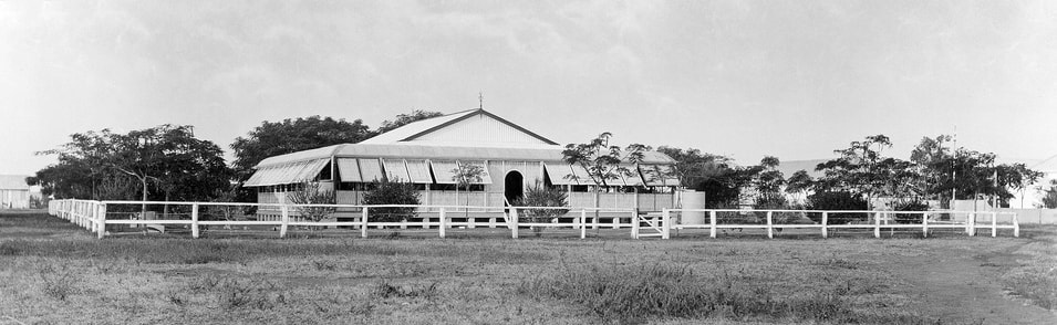
SLSA B-10109 Residence of the Superintendent of the Cable Company. Foelsche 1879 20.8x15.6 a2
|
PIC P827-19 LOC Album 914-1&2-nla.obj-141837157 detail Esplanade SE - 10th June 1875
|
|
Image above shows at left a tree, image decay makes it appear to be a pole. The Residency sporting the 2nd storey is post 1874 and pre 1877 when it was removed courtesy of white ants. The single post at far right - seemingly near the Residency picket fence - appears to have been polled but there is no evidence of any other such poles along the Esplanade or indeed anywhere except in Mitchell Street.
NLNZ 20 Aug 1948 J Kinang Pinterest
|
Detail
|
NLNZ 20 Aug 1948 J Kinang Pinterest
|

Jill Kinang Pinterest 1966
|
Pinterest 1968
|
NLNZ Whites Aviation 20 Aug 1948 WA-15266-F Jill Kinang
|
Bennett Street - OT Poles on West side
SLSA B-8959 Bennett St c1890 16 x 11.2 Looking NE ~Cavanagh Street on left
|
PRG-280-1-4-298 Bennett St 1900c Searcy 2 Looking SW Smith St intersection
|
Darwin 1900 - NTLIS Map Id 1000 Date 1904 6ch to inch
|
NTLIS 1906 Id 989
|
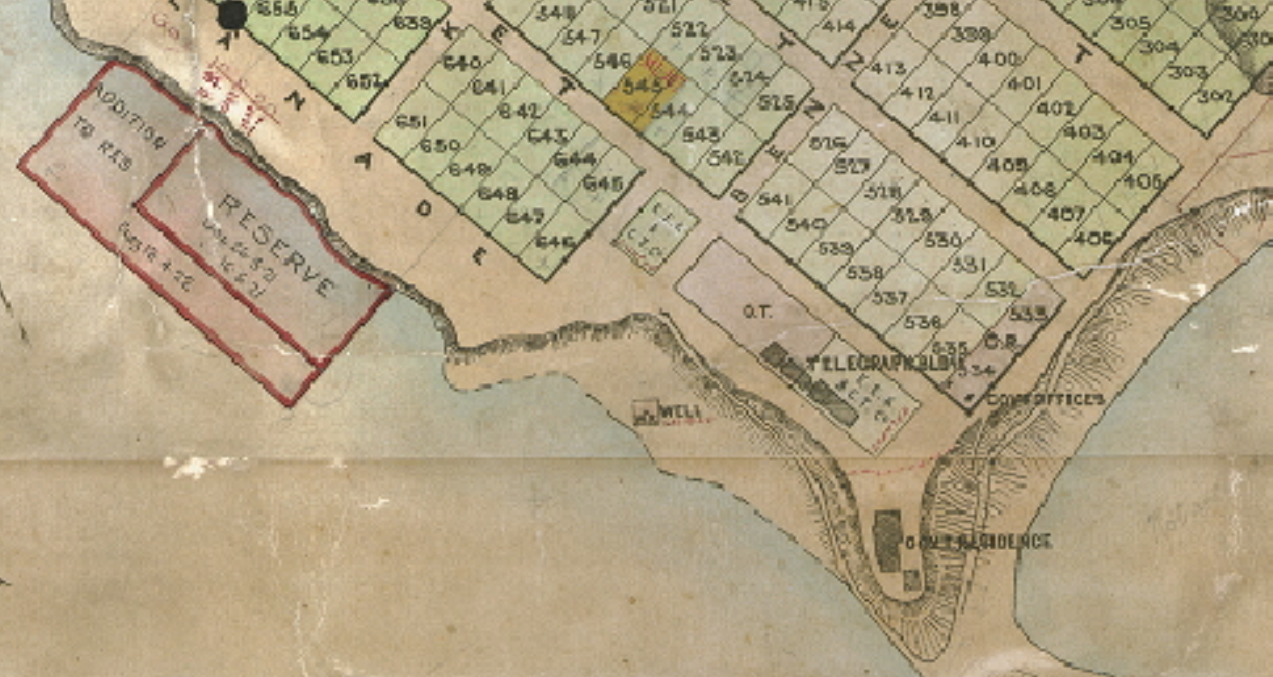
These maps indicate that the OT occupied the area opposite Lots 538 to 541 - being equal to 4 Lots would be 6 chains by 3 chains (if each half-acre Lot is 1.5ch x 3ch) where a Chain is 22 yards - but this does not work exactly and is anyway not required. The dividing fence would therefore be 132 yards from the corner of Mitchell and Bennett Streets - equidistant to the corner of Mitchell St & the SE Esplanade. Irrespective of the dimensions of the half-acre lots the fece dividing the OT from the BAT section is opposite the border between Lots 537 & 538 therefore exactly half way between the curb of the Esplanade and the curb of Bennett Street. Not entirely surprisingly this aligns closely with the piece of wall that survives
NTLIS Plan 2 1891
|

NTLIS VL Solomon plan 1887
NTLIS Plan 2 1891 detail
|
The 1891 plan contains the suggestion that the line crossed Mitchell Street at the back of the Government blocks 533 & 534 which fits with the description of visitors, the Tuck Post Card image by Fullwood and may have informed Alfred Giles. The dotted line may simply denote the Government lots.
SE Esplanade

SLSA B29848(1) Cnr Smith St & Esplanade 8 Jan 1897 looking west
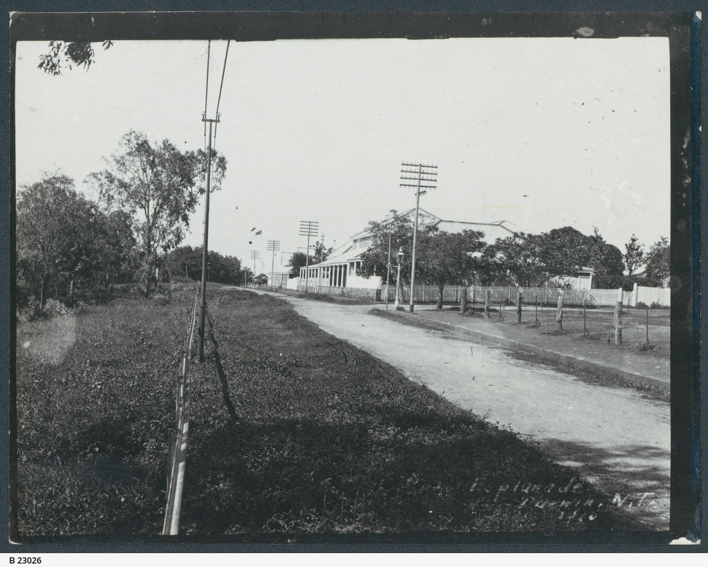
SLSA B-23026 Esplanade 1916
|
|
Proposed Memorial Site
Some reasonable assumptions are not out of place with Sweet's Planting Ceremony photograph which trumped the other sections of the line. A great deal of the nation's history has been cobbled together from newspaper cuttings from far off cities - months after the event - with scant regard to veracity.
It is reasonable to assume that:-
The 1st Pole planted is the one tied to the Tree Pole for the Sweet photo taken in a select company, unlikely to spill the beans & spoil the fun.
That this 1st Pole is actually Pole One of the OT Line if they were numbered sequentially from north to south.
Pole One being the first one to receive wire from the OT/BAT station i.e. the landward NE side of the buildings.
The site of this pole would be at the junction of the OT & BAT blocks and the line of poles run NW to Tree Pole at the crossroads of Bennett & Mitchell Sts.
There is conflicting evidence as to whether the OT/BAT block was divided equally at a point opposite the centre of Lot 538 or disproportionately at a point opposite the boundary of Lots 537 & 538

Detail 1887 Solomon
|
Darwin 1900 - Map Id 1000 Date 1904 6ch to inch
|

Town of Darwin 1916 NTLIS
|
The images below show estimates of where the Pole sites would be in the 2 scenarios - A. at left if the OT/BAT block is slit 50:50 and B. at right if the split is uneven and the line is half way between Lots 534 & 541.

|

|
The architect has sited Parliament House the centre of the OT/BAT block - the centre of double doors at the main entrance is the midline running through to centre of the great hall - through the rear double doors to the grassed balcony overlooking the harbour and the ingress point of the undersea cable.

A lot of thought and expense has gone into the paving at the epicentre of the Parliament forecourt. It would be ungracious not to take advantage of the beautifully paved bullseye to install a brass plaque. Perhaps one day there will be a bronze pole rising from a circular base at coffee cup height with a map of the area from Banjoewangi to Adelaide (nearly) and maybe a linesman aloft fixing the wire to join a line of poles running up to the corner where the Tree Pole one stood for a photo with the great and the good. In a city without a statue of its namesake - a plaque in the paving is better than what's gone before.
References
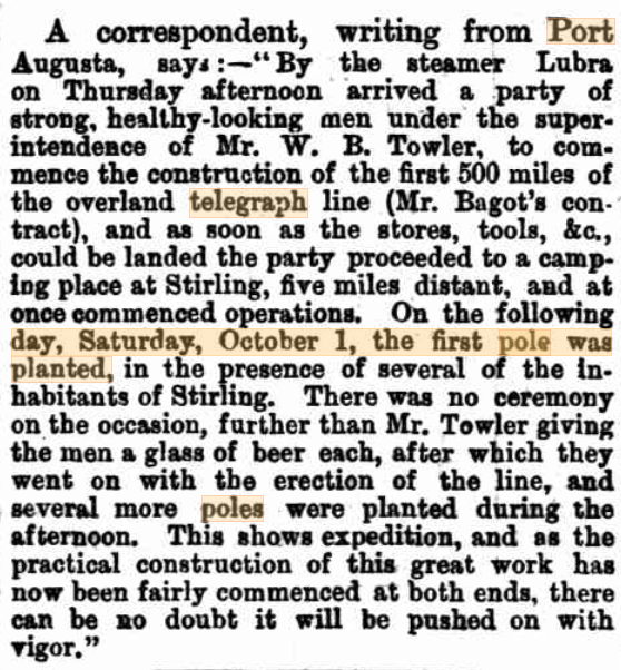
Express & Telegraph Adel 6 Oct 1870 1st southern pole
|
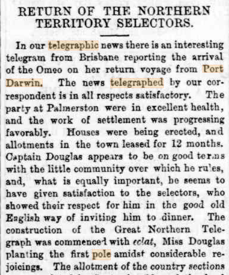
Express & Telegraph Adelaide 5 Oct 1870 1st news 1st pole
|
Fannie Douglas daughter of 1st Resident Bloomfield Douglas GPike NTOT
|
GPike p107 1st pole etc NT OT
|
G Pike p133 NTOT
|
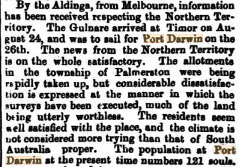
Northern Argus Clare SA 7 Oct 1870
|
p120 GPike NTOT
p132 G Pike NTOT
|
p125 G Pike NTOT
|
Queanbean Age 12-6-1873
|
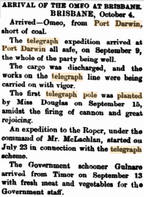
SA Advertiser 5 Oct 1870 cannon!
|
SA Register 5 Oct 1870
|
The BAT Cottage
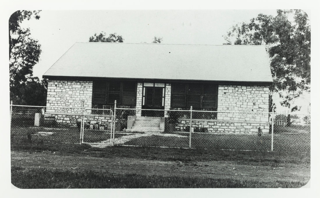
ph0129-0010 BAT Cottage built c1824
|
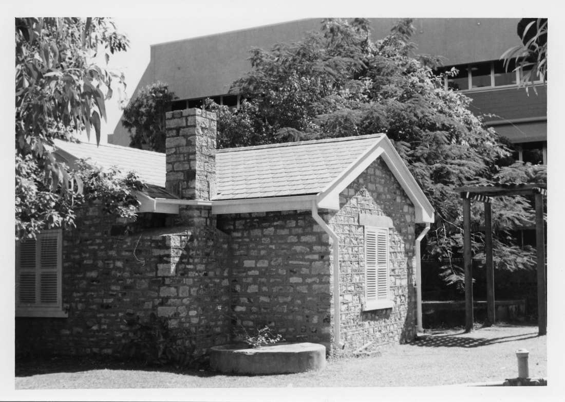
ph0219-0058 BAT Museum, formerly residence of BAT manager, later residence of Lyons family
|
The BAT cottage which once house the BAT Museum - now called Lyons Cottage or something is controlled by MAGNT which itself has no display of OT/BAT artefacts despite it being by far the most significant man-made achievement in the Northern Territory. It houses a coffee shop & a very poor clutter of indigenous crafts. It would make a most excellent OT/BAT Museum.......again.
Additional Images
Parliament House, Darwin NLA catalogue
Description [Darwin] : Government Printer, [1984]
18 leaves, 13 leaves of plates: ill., maps, plans ; 21 x 30 cm.
ISBN 0724503382
Parl House – designed by Architect Tim Rogers, of Meldrum Burrows and Partners Pty Ltd – liquidated -
Parl House tour info – will send email
Description [Darwin] : Government Printer, [1984]
18 leaves, 13 leaves of plates: ill., maps, plans ; 21 x 30 cm.
ISBN 0724503382
Parl House – designed by Architect Tim Rogers, of Meldrum Burrows and Partners Pty Ltd – liquidated -
Parl House tour info – will send email
|
Express & Telegraph Adelaide 5 Oct 1870 1st news 1st pole
|
|
Queanbeyan Age 12-6-1873
|
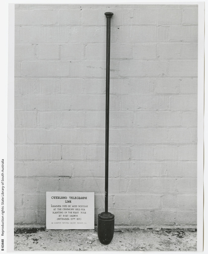
SLSA Harriett's thumper - pristine
|
1887 Map of Palmerston with OT & BAY offices but no 1st OT Pole or Line
|
|
|
OT Memorial Obverse
|
OT Memorial Reverse
|
M. Owen stitch of PIC P827-14 LOC Album 914-1&2-nla.obj-141836657 June 3rd 1875